Olóriz geodata
Olóriz (Navarre) is a seat of a third-order administrative division; located in Spain in Europe/Madrid (GMT+2) time zone. With population of 212 people, there are 4965 cities with bigger population in this country. Compared to other cities in Spain, 90.4% of cities are located further ↓South; 71.9% of cities are located further ←West and 54.7% of cities have higher elevation than Olóriz. Note1


Olóriz GPS coordinates[2]
42° 38' 6.792" North, 1° 36' 45.936" West
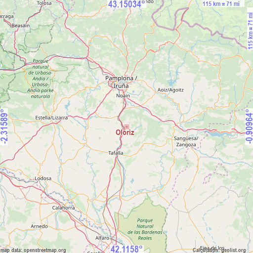
| Map corner | latitude | longitude |
|---|---|---|
| Upper-left | 43.15034°, | -2.31589° |
| Center: | 42.63522°, | -1.61276° |
| Lower-right: | 42.1158°, | -0.90964° |
| Map W x H: | 115×115 km | = 71.5×71.5mi |
| max Lat: | 43.74134° ⇑9.6% North |
| Olóriz: | 42.63522° |
| min Lat: | ⇓90.4% South 27.64134° |
| min Long | Olóriz | max Long |
| -18.00367° | -1.61276° | 4.2899° |
| W 71.9%⇐ | ⇒28.1% E |
Elevation
Elevation of Olóriz is 599 m = 1965 ft, and this is 1 m = 3 ft above average elevation for this country.
| Max E: |
1682 m = 5518 ft | 54.7% |
| Olóriz | 599 m 1965 ft | |
| Avg. | 598 m = 1962 ft | |
Min E: |
0 m = 0 ft | 45.3% |
See also: Spain elevation on elevation.city.
Geographical zone
Olóriz is located in North temperate zone (between Tropic of Cancer and the Arctic Circle). Distance of this Northern Tropic circle is 2134.7 km =1326.4 mi to South.| Distance of | km | miles | from Olóriz |
|---|---|---|---|
| North Pole | 5266.5 | 3272.5 | to North |
| Arctic Circle | 2660.6 | 1653.2 | to North |
| Tropic Cancer | 2134.7 | 1326.4 | to South |
| Equator | 4740.6 | 2945.7 | to South |


Nearby cities:
15 places around Olóriz: (largest is in red/bold)
• Adiós
11.5 km =7.1 mi,  299°
299°
• Añorbe
8.7 km =5.4 mi,  286°
286°
• Barásoain
4.5 km =2.8 mi,  218°
218°
• Beriáin
11.2 km =7 mi,  346°
346°
• Elorz
11.6 km =7.2 mi,  21°
21°
• Enériz
10.2 km =6.3 mi, 292°
• Garínoain
4.7 km =2.9 mi,  213°
213°
• Lerga
11.8 km =7.3 mi,  129°
129°
• Monreal
11.5 km =7.1 mi,  48°
48°
• Orísoain
3.8 km =2.4 mi,  169°
169°
• Pueyo
8.3 km =5.2 mi,  200°
200°
• San Martín de Unx
13 km =8.1 mi,  160°
160°
• Tafalla
13.1 km =8.1 mi, 202°
• Tirapu
7.8 km =4.8 mi, 288°
• Unzué
2.2 km =1.4 mi,  330°
330°
Sources, notices
• [Note1] Compared only with cities in Spain existing in our database
• [Src1] Map data: © OpenStreetMap contributors (CC-BY-SA)
• [Src2] Other city data from geonames.org with taken over terms of usage.
• [Src3] Geographical zone / Annual Mean Temperature by Robert A. Rohde @ Wikipedia
