Retamar geodata
Retamar (Andalusia) is a populated place; located in Spain in Europe/Madrid (GMT+2) time zone. With population of 4,487 people, there are 1387 cities with bigger population in this country. Compared to other cities in Spain, 96.6% of cities are located further ↑North; 63.2% of cities are located further ←West and 99.8% of cities have higher elevation than Retamar. Note1


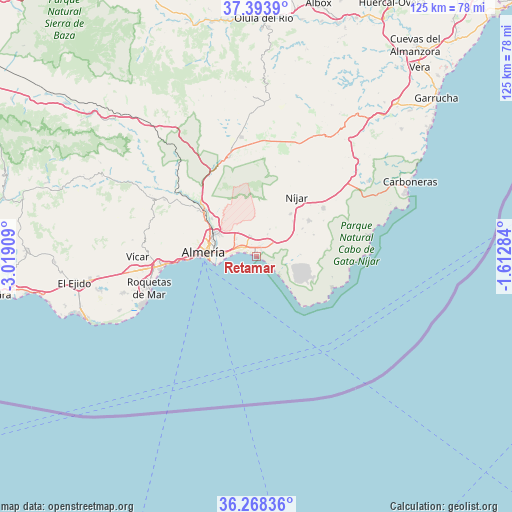
Retamar GPS coordinates[2]
36° 49' 59.52" North, 2° 18' 57.492" West
| Map corner | latitude | longitude |
|---|---|---|
| Upper-left | 37.3939°, | -3.01909° |
| Center: | 36.8332°, | -2.31597° |
| Lower-right: | 36.26836°, | -1.61284° |
| Map W x H: | 125.1×125.1 km | = 77.7×77.7mi |
| max Lat: | 43.74134° ⇑96.6% North |
| Retamar: | 36.8332° |
| min Lat: | ⇓3.4% South 27.64134° |
| min Long | Retamar | max Long |
| -18.00367° | -2.31597° | 4.2899° |
| W 63.2%⇐ | ⇒36.8% E |
Elevation
Elevation of Retamar is 3 m = 10 ft, and this is 595 m = 1952 ft below average elevation for this country.
| Max E: |
1682 m = 5518 ft | 99.8% |
| Avg. | 598 m = 1962 ft | |
| Retamar | 3 m = 10 ft | |
Min E: |
0 m = 0 ft | 0.2% |
See also: Spain elevation on elevation.city.
Geographical zone
Retamar is located in North temperate zone (between Tropic of Cancer and the Arctic Circle). Distance of this Northern Tropic circle is 1489.5 km =925.5 mi to South.| Distance of | km | miles | from Retamar |
|---|---|---|---|
| North Pole | 5911.6 | 3673.3 | to North |
| Arctic Circle | 3305.7 | 2054.1 | to North |
| Tropic Cancer | 1489.5 | 925.5 | to South |
| Equator | 4095.5 | 2544.8 | to South |


Nearby cities:
15 places around Retamar: (largest is in red/bold)
• Aguadulce
22.9 km =14.2 mi,  264°
264°
• Almería
12.8 km =8 mi,  272°
272°
• Benahadux
16.3 km =10.1 mi,  308°
308°
• Costacabana
5.8 km =3.6 mi,  275°
275°
• Gádor
20.6 km =12.8 mi, 310°
• Huércal de Almería
12.3 km =7.6 mi,  298°
298°
• Lucainena de las Torres
25.2 km =15.7 mi,  23°
23°
• Níjar
17.8 km =11.1 mi,  33°
33°
• Pechina
14.2 km =8.8 mi, 310°
• Rioja
18 km =11.2 mi, 313°
• San José
20.1 km =12.5 mi,  113°
113°
• Santa Fe de Mondújar
24.8 km =15.4 mi, 309°
• Tabernas
25 km =15.5 mi,  344°
344°
• Turrillas
22.3 km =13.9 mi,  11°
11°
• Viator
11.7 km =7.3 mi, 302°
Sources, notices
• [Note1] Compared only with cities in Spain existing in our database
• [Src1] Map data: © OpenStreetMap contributors (CC-BY-SA)
• [Src2] Other city data from geonames.org with taken over terms of usage.
• [Src3] Geographical zone / Annual Mean Temperature by Robert A. Rohde @ Wikipedia
