Costacabana geodata
Costacabana (Andalusia) is a populated place; located in Spain in Europe/Madrid (GMT+2) time zone. With population of 1,209 people, there are 2718 cities with bigger population in this country. Compared to other cities in Spain, 96.5% of cities are located further ↑North; 62.5% of cities are located further ←West and 99.5% of cities have higher elevation than Costacabana. Note1


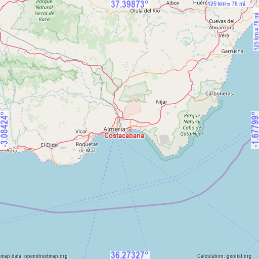
Costacabana GPS coordinates[2]
36° 50' 17.052" North, 2° 22' 51.996" West
| Map corner | latitude | longitude |
|---|---|---|
| Upper-left | 37.39873°, | -3.08424° |
| Center: | 36.83807°, | -2.38111° |
| Lower-right: | 36.27327°, | -1.67799° |
| Map W x H: | 125.1×125.1 km | = 77.7×77.7mi |
| max Lat: | 43.74134° ⇑96.5% North |
| Costacabana: | 36.83807° |
| min Lat: | ⇓3.5% South 27.64134° |
| min Long | Costacabana | max Long |
| -18.00367° | -2.38111° | 4.2899° |
| W 62.5%⇐ | ⇒37.5% E |
Elevation
Elevation of Costacabana is 6 m = 20 ft, and this is 592 m = 1942 ft below average elevation for this country.
| Max E: |
1682 m = 5518 ft | 99.5% |
| Avg. | 598 m = 1962 ft | |
| Costacabana | 6 m = 20 ft | |
Min E: |
0 m = 0 ft | 0.5% |
See also: Spain elevation on elevation.city.
Geographical zone
Costacabana is located in North temperate zone (between Tropic of Cancer and the Arctic Circle). Distance of this Northern Tropic circle is 1490.1 km =925.9 mi to South.| Distance of | km | miles | from Costacabana |
|---|---|---|---|
| North Pole | 5911.1 | 3673 | to North |
| Arctic Circle | 3305.2 | 2053.8 | to North |
| Tropic Cancer | 1490.1 | 925.9 | to South |
| Equator | 4096 | 2545.1 | to South |


Nearby cities:
15 places around Costacabana: (largest is in red/bold)
• Aguadulce
17.2 km =10.7 mi,  261°
261°
• Alhama de Almería
21.3 km =13.2 mi,  308°
308°
• Almería
7 km =4.3 mi,  270°
270°
• Benahadux
11.9 km =7.4 mi,  324°
324°
• Enix
20.1 km =12.5 mi,  282°
282°
• Gádor
16.2 km =10.1 mi, 322°
• Huércal de Almería
7.3 km =4.5 mi, 316°
• La Gangosa Vistasol
21.7 km =13.5 mi, 260°
• Níjar
21.1 km =13.1 mi,  47°
47°
• Pechina
10 km =6.2 mi,  330°
330°
• Retamar
5.8 km =3.6 mi,  95°
95°
• Rioja
14 km =8.7 mi, 328°
• Roquetas de Mar
22.4 km =13.9 mi,  248°
248°
• Santa Fe de Mondújar
20.2 km =12.6 mi, 318°
• Viator
7.1 km =4.4 mi, 324°
Sources, notices
• [Note1] Compared only with cities in Spain existing in our database
• [Src1] Map data: © OpenStreetMap contributors (CC-BY-SA)
• [Src2] Other city data from geonames.org with taken over terms of usage.
• [Src3] Geographical zone / Annual Mean Temperature by Robert A. Rohde @ Wikipedia
