Tabernas geodata
Tabernas (Andalusia) is a seat of a third-order administrative division; located in Spain in Europe/Madrid (GMT+2) time zone. With population of 3,241 people, there are 1647 cities with bigger population in this country. Compared to other cities in Spain, 94.9% of cities are located further ↑North; 62.4% of cities are located further ←West and 68.6% of cities have higher elevation than Tabernas. Note1


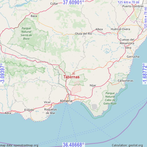
Tabernas GPS coordinates[2]
37° 2' 59.712" North, 2° 23' 27.024" West
| Map corner | latitude | longitude |
|---|---|---|
| Upper-left | 37.60901°, | -3.09397° |
| Center: | 37.04992°, | -2.39084° |
| Lower-right: | 36.48668°, | -1.68772° |
| Map W x H: | 124.8×124.8 km | = 77.5×77.5mi |
| max Lat: | 43.74134° ⇑94.9% North |
| Tabernas: | 37.04992° |
| min Lat: | ⇓5.1% South 27.64134° |
| min Long | Tabernas | max Long |
| -18.00367° | -2.39084° | 4.2899° |
| W 62.4%⇐ | ⇒37.6% E |
Elevation
Elevation of Tabernas is 404 m = 1325 ft, and this is 194 m = 636 ft below average elevation for this country.
| Max E: |
1682 m = 5518 ft | 68.6% |
| Avg. | 598 m = 1962 ft | |
| Tabernas | 404 m = 1325 ft | |
Min E: |
0 m = 0 ft | 31.4% |
See also: Spain elevation on elevation.city.
Geographical zone
Tabernas is located in North temperate zone (between Tropic of Cancer and the Arctic Circle). Distance of this Northern Tropic circle is 1513.6 km =940.5 mi to South.| Distance of | km | miles | from Tabernas |
|---|---|---|---|
| North Pole | 5887.5 | 3658.3 | to North |
| Arctic Circle | 3281.6 | 2039.1 | to North |
| Tropic Cancer | 1513.6 | 940.5 | to South |
| Equator | 4119.6 | 2559.8 | to South |


Nearby cities:
15 places around Tabernas: (largest is in red/bold)
• Alhabia
18.6 km =11.6 mi,  249°
249°
• Benahadux
15.2 km =9.4 mi,  203°
203°
• Castro de Filabres
15.6 km =9.7 mi,  343°
343°
• Gádor
14 km =8.7 mi,  220°
220°
• Gérgal
15.3 km =9.5 mi,  300°
300°
• Huércal de Almería
18.8 km =11.7 mi,  192°
192°
• Lucainena de las Torres
16.9 km =10.5 mi,  93°
93°
• Níjar
18.9 km =11.7 mi,  119°
119°
• Olula de Castro
15.7 km =9.8 mi,  331°
331°
• Pechina
15.4 km =9.6 mi, 195°
• Rioja
13.3 km =8.3 mi,  208°
208°
• Santa Fe de Mondújar
15 km =9.3 mi,  236°
236°
• Turrillas
11.3 km =7 mi,  101°
101°
• Velefique
16.1 km =10 mi,  356°
356°
• Viator
18.1 km =11.2 mi, 190°
Sources, notices
• [Note1] Compared only with cities in Spain existing in our database
• [Src1] Map data: © OpenStreetMap contributors (CC-BY-SA)
• [Src2] Other city data from geonames.org with taken over terms of usage.
• [Src3] Geographical zone / Annual Mean Temperature by Robert A. Rohde @ Wikipedia
