Ruotsinpyhtää geodata
Ruotsinpyhtää (Uusimaa) is a populated place; located in Finland in Europe/Helsinki (GMT+3) time zone. With population of 2,836 people, there are 307 cities with bigger population in this country. Compared to other cities in Finland, 84.2% of cities are located further ↑North; 75% of cities are located further ←West and 86.1% of cities have higher elevation than Ruotsinpyhtää. Note1


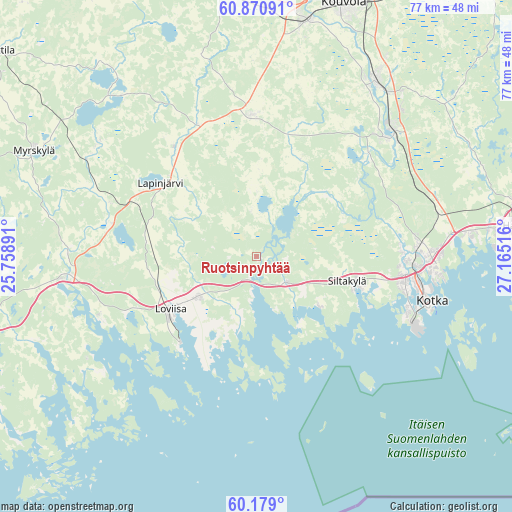
Ruotsinpyhtää GPS coordinates[2]
60° 31' 36.48" North, 26° 27' 43.308" East
| Map corner | latitude | longitude |
|---|---|---|
| Upper-left | 60.87091°, | 25.75891° |
| Center: | 60.5268°, | 26.46203° |
| Lower-right: | 60.179°, | 27.16516° |
| Map W x H: | 76.9×76.9 km | = 47.8×47.8mi |
| max Lat: | 69.90864° ⇑84.2% North |
| Ruotsinpyhtää: | 60.5268° |
| min Lat: | ⇓15.8% South 59.83333° |
| min Long | Ruotsinpyhtää | max Long |
| 21.2° | 26.46203° | 30.93276° |
| W 75%⇐ | ⇒25% E |
Elevation
Elevation of Ruotsinpyhtää is 15 m = 49 ft, and this is 62.1 m = 204 ft below average elevation for this country.
| Max E: |
299 m = 981 ft | 86.1% |
| Avg. | 77.1 m = 253 ft | |
| Ruotsinpyhtää | 15 m = 49 ft | |
Min E: |
1 m = 3 ft | 13.9% |
See also: Finland elevation on elevation.city.
Geographical zone
Ruotsinpyhtää is located in North temperate zone (between Tropic of Cancer and the Arctic Circle). Distance of this North polar circle is 671.2 km =417.1 mi to North.| Distance of | km | miles | from Ruotsinpyhtää |
|---|---|---|---|
| North Pole | 3277.1 | 2036.3 | to North |
| Arctic Circle | 671.2 | 417.1 | to North |
| Tropic Cancer | 4124 | 2562.5 | to South |
| Equator | 6729.9 | 4181.8 | to South |


Nearby cities:
15 places around Ruotsinpyhtää: (largest is in red/bold)
• Anjala
26.7 km =16.6 mi,  49°
49°
• Artjärvi
32.3 km =20.1 mi,  318°
318°
• Broby
14.3 km =8.9 mi,  102°
102°
• Elimäki
21.1 km =13.1 mi,  0°
0°
• Hamina
40.5 km =25.2 mi,  83°
83°
• Karhula
25.7 km =16 mi,  91°
91°
• Katariina
27.6 km =17.1 mi,  107°
107°
• Kotka
27.3 km =17 mi, 104°
• Kouvola
39.9 km =24.8 mi,  18°
18°
• Lapinjärvi
18.1 km =11.2 mi,  306°
306°
• Liljendal
23 km =14.3 mi,  283°
283°
• Lovisa
15.1 km =9.4 mi,  238°
238°
• Myrskylä
37.1 km =23.1 mi,  295°
295°
• Pernå
25.1 km =15.6 mi,  249°
249°
• Pyhtää
5.8 km =3.6 mi,  129°
129°
Sources, notices
• [Note1] Compared only with cities in Finland existing in our database
• [Src1] Map data: © OpenStreetMap contributors (CC-BY-SA)
• [Src2] Other city data from geonames.org with taken over terms of usage.
• [Src3] Geographical zone / Annual Mean Temperature by Robert A. Rohde @ Wikipedia
