Elimäki geodata
Elimäki (Kymenlaakso) is a seat of a third-order administrative division; located in Finland in Europe/Helsinki (GMT+3) time zone. With population of 8,751 people, there are 127 cities with bigger population in this country. Compared to other cities in Finland, 76.9% of cities are located further ↑North; 75.2% of cities are located further ←West and 72.6% of cities have higher elevation than Elimäki. Note1


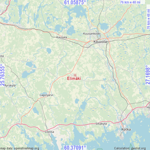
Elimäki GPS coordinates[2]
60° 43' 0.012" North, 26° 28' 0.012" East
| Map corner | latitude | longitude |
|---|---|---|
| Upper-left | 61.05875°, | 25.76355° |
| Center: | 60.71667°, | 26.46667° |
| Lower-right: | 60.37091°, | 27.1698° |
| Map W x H: | 76.5×76.5 km | = 47.5×47.5mi |
| max Lat: | 69.90864° ⇑76.9% North |
| Elimäki: | 60.71667° |
| min Lat: | ⇓23.1% South 59.83333° |
| min Long | Elimäki | max Long |
| 21.2° | 26.46667° | 30.93276° |
| W 75.2%⇐ | ⇒24.8% E |
Elevation
Elevation of Elimäki is 34 m = 112 ft, and this is 43.1 m = 141 ft below average elevation for this country.
| Max E: |
299 m = 981 ft | 72.6% |
| Avg. | 77.1 m = 253 ft | |
| Elimäki | 34 m = 112 ft | |
Min E: |
1 m = 3 ft | 27.4% |
See also: Finland elevation on elevation.city.
Geographical zone
Elimäki is located in North temperate zone (between Tropic of Cancer and the Arctic Circle). Distance of this North polar circle is 650.1 km =404 mi to North.| Distance of | km | miles | from Elimäki |
|---|---|---|---|
| North Pole | 3256 | 2023.2 | to North |
| Arctic Circle | 650.1 | 404 | to North |
| Tropic Cancer | 4145.1 | 2575.6 | to South |
| Equator | 6751.1 | 4194.9 | to South |


Nearby cities:
15 places around Elimäki: (largest is in red/bold)
• Anjala
20.3 km =12.6 mi,  100°
100°
• Artjärvi
21.8 km =13.5 mi,  278°
278°
• Broby
27.7 km =17.2 mi,  150°
150°
• Iitti
21 km =13 mi,  340°
340°
• Jaala
37.4 km =23.2 mi,  1°
1°
• Karhula
33.4 km =20.8 mi,  130°
130°
• Kotka
38.2 km =23.7 mi,  136°
136°
• Kouvola
20.9 km =13 mi,  37°
37°
• Lapinjärvi
17.9 km =11.1 mi,  235°
235°
• Liljendal
27.6 km =17.1 mi,  234°
234°
• Lovisa
31.8 km =19.8 mi,  204°
204°
• Myrskylä
34.1 km =21.2 mi,  261°
261°
• Pernå
38.1 km =23.7 mi,  218°
218°
• Pyhtää
25.2 km =15.7 mi,  170°
170°
• Ruotsinpyhtää
21.1 km =13.1 mi,  180°
180°
Sources, notices
• [Note1] Compared only with cities in Finland existing in our database
• [Src1] Map data: © OpenStreetMap contributors (CC-BY-SA)
• [Src2] Other city data from geonames.org with taken over terms of usage.
• [Src3] Geographical zone / Annual Mean Temperature by Robert A. Rohde @ Wikipedia
