Parikkala geodata
Parikkala (South Karelia) is a seat of a third-order administrative division; located in Finland in Europe/Helsinki (GMT+3) time zone. With population of 4,274 people, there are 239 cities with bigger population in this country. Compared to other cities in Finland, 55.1% of cities are located further ↑North; 96.8% of cities are located further ←West and 64.3% of cities have lower elevation than Parikkala. Note1


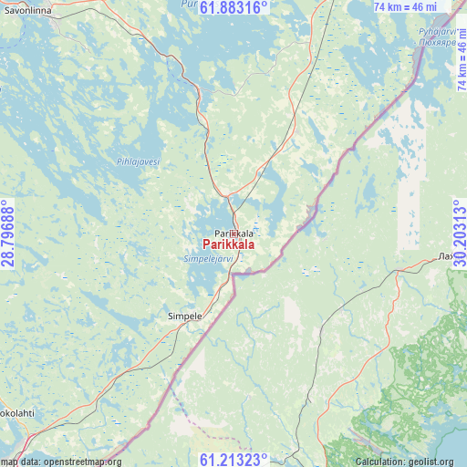
Parikkala GPS coordinates[2]
61° 33' 0" North, 29° 30' 0" East
| Map corner | latitude | longitude |
|---|---|---|
| Upper-left | 61.88316°, | 28.79688° |
| Center: | 61.55°, | 29.5° |
| Lower-right: | 61.21323°, | 30.20313° |
| Map W x H: | 74.5×74.5 km | = 46.3×46.3mi |
| max Lat: | 69.90864° ⇑55.1% North |
| Parikkala: | 61.55° |
| min Lat: | ⇓44.9% South 59.83333° |
| min Long | Parikkala | max Long |
| 21.2° | 29.5° | 30.93276° |
| W 96.8%⇐ | ⇒3.2% E |
Elevation
Elevation of Parikkala is 100 m = 328 ft, and this is 22.9 m = 75 ft above average elevation for this country.
| Max E: |
299 m = 981 ft | 35.7% |
| Parikkala | 100 m 328 ft | |
| Avg. | 77.1 m = 253 ft | |
Min E: |
1 m = 3 ft | 64.3% |
See also: Finland elevation on elevation.city.
Geographical zone
Parikkala is located in North temperate zone (between Tropic of Cancer and the Arctic Circle). Distance of this North polar circle is 557.5 km =346.4 mi to North.| Distance of | km | miles | from Parikkala |
|---|---|---|---|
| North Pole | 3163.3 | 1965.6 | to North |
| Arctic Circle | 557.5 | 346.4 | to North |
| Tropic Cancer | 4237.8 | 2633.2 | to South |
| Equator | 6843.7 | 4252.5 | to South |


Nearby cities:
15 places around Parikkala: (largest is in red/bold)
• Enonkoski
66.3 km =41.2 mi,  333°
333°
• Imatra
57.9 km =36 mi,  223°
223°
• Joutseno
71.5 km =44.4 mi,  227°
227°
• Kerimäki
41.7 km =25.9 mi,  344°
344°
• Kesälahti
42.5 km =26.4 mi,  24°
24°
• Kitee
70 km =43.5 mi,  29°
29°
• Punkaharju
24 km =14.9 mi,  345°
345°
• Puumala
70.3 km =43.7 mi,  267°
267°
• Rautjärvi
15.2 km =9.4 mi,  211°
211°
• Ruokolahti
46.2 km =28.7 mi, 230°
• Saari
17.3 km =10.7 mi,  49°
49°
• Savonlinna
48.3 km =30 mi,  317°
317°
• Simpele
14.8 km =9.2 mi, 208°
• Sulkava
65 km =40.4 mi,  293°
293°
• Uukuniemi
37.5 km =23.3 mi, 45°
Sources, notices
• [Note1] Compared only with cities in Finland existing in our database
• [Src1] Map data: © OpenStreetMap contributors (CC-BY-SA)
• [Src2] Other city data from geonames.org with taken over terms of usage.
• [Src3] Geographical zone / Annual Mean Temperature by Robert A. Rohde @ Wikipedia
