Kesälahti geodata
Kesälahti (North Karelia) is a populated place; located in Finland in Europe/Helsinki (GMT+3) time zone. With population of 2,665 people, there are 316 cities with bigger population in this country. Compared to other cities in Finland, 51.1% of cities are located further ↓South; 97.9% of cities are located further ←West and 52.4% of cities have lower elevation than Kesälahti. Note1


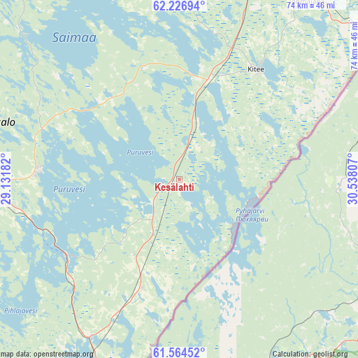
Kesälahti GPS coordinates[2]
61° 53' 51.072" North, 29° 50' 5.784" East
| Map corner | latitude | longitude |
|---|---|---|
| Upper-left | 62.22694°, | 29.13182° |
| Center: | 61.89752°, | 29.83494° |
| Lower-right: | 61.56452°, | 30.53807° |
| Map W x H: | 73.7×73.7 km | = 45.8×45.8mi |
| max Lat: | 69.90864° ⇑48.9% North |
| Kesälahti: | 61.89752° |
| min Lat: | ⇓51.1% South 59.83333° |
| min Long | Kesälahti | max Long |
| 21.2° | 29.83494° | 30.93276° |
| W 97.9%⇐ | ⇒2.1% E |
Elevation
Elevation of Kesälahti is 84 m = 276 ft, and this is 6.9 m = 23 ft above average elevation for this country.
| Max E: |
299 m = 981 ft | 47.6% |
| Kesälahti | 84 m 276 ft | |
| Avg. | 77.1 m = 253 ft | |
Min E: |
1 m = 3 ft | 52.4% |
See also: Finland elevation on elevation.city.
Geographical zone
Kesälahti is located in North temperate zone (between Tropic of Cancer and the Arctic Circle). Distance of this North polar circle is 518.8 km =322.4 mi to North.| Distance of | km | miles | from Kesälahti |
|---|---|---|---|
| North Pole | 3124.7 | 1941.6 | to North |
| Arctic Circle | 518.8 | 322.4 | to North |
| Tropic Cancer | 4276.4 | 2657.2 | to South |
| Equator | 6882.4 | 4276.5 | to South |


Nearby cities:
15 places around Kesälahti: (largest is in red/bold)
• Enonkoski
51.4 km =31.9 mi,  293°
293°
• Kerimäki
29 km =18 mi,  272°
272°
• Kiihtelysvaara
69.9 km =43.4 mi,  17°
17°
• Kitee
27.9 km =17.3 mi,  36°
36°
• Parikkala
42.5 km =26.4 mi,  204°
204°
• Punkaharju
28.1 km =17.5 mi,  236°
236°
• Pyhäselkä
60 km =37.3 mi,  6°
6°
• Rautjärvi
57.6 km =35.8 mi,  206°
206°
• Rääkkylä
48 km =29.8 mi,  346°
346°
• Saari
27.9 km =17.3 mi,  189°
189°
• Savonlinna
50.1 km =31.1 mi, 266°
• Savonranta
45.9 km =28.5 mi,  313°
313°
• Simpele
57.2 km =35.5 mi, 205°
• Tohmajärvi
42.7 km =26.5 mi, 41°
• Uukuniemi
15.3 km =9.5 mi,  143°
143°
Sources, notices
• [Note1] Compared only with cities in Finland existing in our database
• [Src1] Map data: © OpenStreetMap contributors (CC-BY-SA)
• [Src2] Other city data from geonames.org with taken over terms of usage.
• [Src3] Geographical zone / Annual Mean Temperature by Robert A. Rohde @ Wikipedia
