Saari geodata
Saari (South Karelia) is a populated place; located in Finland in Europe/Helsinki (GMT+3) time zone. With population of 1,326 people, there are 406 cities with bigger population in this country. Compared to other cities in Finland, 53.2% of cities are located further ↑North; 97.4% of cities are located further ←West and 52.6% of cities have higher elevation than Saari. Note1


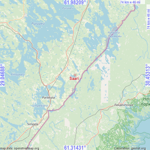
Saari GPS coordinates[2]
61° 39' 0" North, 29° 45' 0" East
| Map corner | latitude | longitude |
|---|---|---|
| Upper-left | 61.98209°, | 29.04688° |
| Center: | 61.65°, | 29.75° |
| Lower-right: | 61.31431°, | 30.45313° |
| Map W x H: | 74.3×74.2 km | = 46.2×46.1mi |
| max Lat: | 69.90864° ⇑53.2% North |
| Saari: | 61.65° |
| min Lat: | ⇓46.8% South 59.83333° |
| min Long | Saari | max Long |
| 21.2° | 29.75° | 30.93276° |
| W 97.4%⇐ | ⇒2.6% E |
Elevation
Elevation of Saari is 76 m = 249 ft, and this is 1.1 m = 4 ft below average elevation for this country.
| Max E: |
299 m = 981 ft | 52.6% |
| Avg. | 77.1 m = 253 ft | |
| Saari | 76 m = 249 ft | |
Min E: |
1 m = 3 ft | 47.4% |
See also: Finland elevation on elevation.city.
Geographical zone
Saari is located in North temperate zone (between Tropic of Cancer and the Arctic Circle). Distance of this North polar circle is 546.3 km =339.5 mi to North.| Distance of | km | miles | from Saari |
|---|---|---|---|
| North Pole | 3152.2 | 1958.7 | to North |
| Arctic Circle | 546.3 | 339.5 | to North |
| Tropic Cancer | 4248.9 | 2640.1 | to South |
| Equator | 6854.8 | 4259.4 | to South |


Nearby cities:
15 places around Saari: (largest is in red/bold)
• Enonkoski
64.5 km =40.1 mi,  318°
318°
• Kerimäki
38 km =23.6 mi, 319°
• Kesälahti
27.9 km =17.3 mi,  9°
9°
• Kitee
54.3 km =33.7 mi,  22°
22°
• Parikkala
17.3 km =10.7 mi,  229°
229°
• Punkaharju
22.6 km =14 mi,  302°
302°
• Rautjärvi
32.1 km =19.9 mi,  221°
221°
• Ruokolahti
63.5 km =39.5 mi, 230°
• Rääkkylä
74.5 km =46.3 mi,  354°
354°
• Savonlinna
51.9 km =32.2 mi, 298°
• Savonranta
65.9 km =40.9 mi,  334°
334°
• Simpele
31.5 km =19.6 mi, 220°
• Sulkava
74.1 km =46 mi,  281°
281°
• Tohmajärvi
67.9 km =42.2 mi,  29°
29°
• Uukuniemi
20.4 km =12.7 mi,  41°
41°
Sources, notices
• [Note1] Compared only with cities in Finland existing in our database
• [Src1] Map data: © OpenStreetMap contributors (CC-BY-SA)
• [Src2] Other city data from geonames.org with taken over terms of usage.
• [Src3] Geographical zone / Annual Mean Temperature by Robert A. Rohde @ Wikipedia
