Kitee geodata
Kitee (North Karelia) is a seat of a third-order administrative division; located in Finland in Europe/Helsinki (GMT+3) time zone. With population of 9,777 people, there are 109 cities with bigger population in this country. Compared to other cities in Finland, 54.3% of cities are located further ↓South; 98.9% of cities are located further ←West and 58.1% of cities have higher elevation than Kitee. Note1


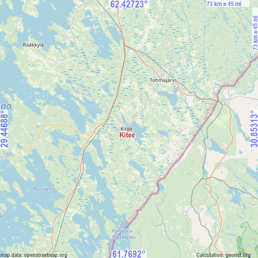
Kitee GPS coordinates[2]
62° 6' 0" North, 30° 9' 0" East
| Map corner | latitude | longitude |
|---|---|---|
| Upper-left | 62.42723°, | 29.44688° |
| Center: | 62.1°, | 30.15° |
| Lower-right: | 61.7692°, | 30.85313° |
| Map W x H: | 73.2×73.2 km | = 45.5×45.5mi |
| max Lat: | 69.90864° ⇑45.7% North |
| Kitee: | 62.1° |
| min Lat: | ⇓54.3% South 59.83333° |
| min Long | Kitee | max Long |
| 21.2° | 30.15° | 30.93276° |
| W 98.9%⇐ | ⇒1.1% E |
Elevation
Elevation of Kitee is 66 m = 217 ft, and this is 11.1 m = 36 ft below average elevation for this country.
| Max E: |
299 m = 981 ft | 58.1% |
| Avg. | 77.1 m = 253 ft | |
| Kitee | 66 m = 217 ft | |
Min E: |
1 m = 3 ft | 41.9% |
See also: Finland elevation on elevation.city.
Geographical zone
Kitee is located in North temperate zone (between Tropic of Cancer and the Arctic Circle). Distance of this North polar circle is 496.3 km =308.4 mi to North.| Distance of | km | miles | from Kitee |
|---|---|---|---|
| North Pole | 3102.2 | 1927.6 | to North |
| Arctic Circle | 496.3 | 308.4 | to North |
| Tropic Cancer | 4299 | 2671.3 | to South |
| Equator | 6904.9 | 4290.5 | to South |


Nearby cities:
15 places around Kitee: (largest is in red/bold)
• Enonkoski
63.3 km =39.3 mi,  268°
268°
• Joensuu
59.2 km =36.8 mi,  340°
340°
• Kerimäki
49.9 km =31 mi,  245°
245°
• Kesälahti
27.9 km =17.3 mi,  216°
216°
• Kiihtelysvaara
44.3 km =27.5 mi,  6°
6°
• Liperi
62.9 km =39.1 mi,  319°
319°
• Parikkala
70 km =43.5 mi,  209°
209°
• Punkaharju
55 km =34.2 mi,  226°
226°
• Pyhäselkä
38.3 km =23.8 mi,  345°
345°
• Rääkkylä
36.7 km =22.8 mi,  311°
311°
• Saari
54.3 km =33.7 mi,  202°
202°
• Savonranta
50.2 km =31.2 mi,  280°
280°
• Tohmajärvi
15.3 km =9.5 mi,  52°
52°
• Tuupovaara
49.3 km =30.6 mi,  30°
30°
• Uukuniemi
35.6 km =22.1 mi,  192°
192°
Sources, notices
• [Note1] Compared only with cities in Finland existing in our database
• [Src1] Map data: © OpenStreetMap contributors (CC-BY-SA)
• [Src2] Other city data from geonames.org with taken over terms of usage.
• [Src3] Geographical zone / Annual Mean Temperature by Robert A. Rohde @ Wikipedia
