Punkaharju geodata
Punkaharju (South Savo) is a populated place; located in Finland in Europe/Helsinki (GMT+3) time zone. With population of 3,984 people, there are 247 cities with bigger population in this country. Compared to other cities in Finland, 51.7% of cities are located further ↑North; 96.6% of cities are located further ←West and 58.8% of cities have higher elevation than Punkaharju. Note1


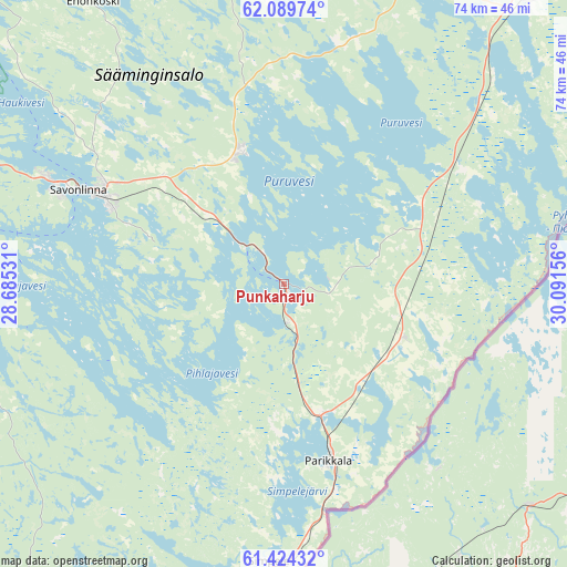
Punkaharju GPS coordinates[2]
61° 45' 31.788" North, 29° 23' 18.348" East
| Map corner | latitude | longitude |
|---|---|---|
| Upper-left | 62.08974°, | 28.68531° |
| Center: | 61.75883°, | 29.38843° |
| Lower-right: | 61.42432°, | 30.09156° |
| Map W x H: | 74×74 km | = 46×46mi |
| max Lat: | 69.90864° ⇑51.7% North |
| Punkaharju: | 61.75883° |
| min Lat: | ⇓48.3% South 59.83333° |
| min Long | Punkaharju | max Long |
| 21.2° | 29.38843° | 30.93276° |
| W 96.6%⇐ | ⇒3.4% E |
Elevation
Elevation of Punkaharju is 64 m = 210 ft, and this is 13.1 m = 43 ft below average elevation for this country.
| Max E: |
299 m = 981 ft | 58.8% |
| Avg. | 77.1 m = 253 ft | |
| Punkaharju | 64 m = 210 ft | |
Min E: |
1 m = 3 ft | 41.2% |
See also: Finland elevation on elevation.city.
Geographical zone
Punkaharju is located in North temperate zone (between Tropic of Cancer and the Arctic Circle). Distance of this North polar circle is 534.2 km =331.9 mi to North.| Distance of | km | miles | from Punkaharju |
|---|---|---|---|
| North Pole | 3140.1 | 1951.2 | to North |
| Arctic Circle | 534.2 | 331.9 | to North |
| Tropic Cancer | 4261 | 2647.7 | to South |
| Equator | 6866.9 | 4266.9 | to South |


Nearby cities:
15 places around Punkaharju: (largest is in red/bold)
• Enonkoski
43.2 km =26.8 mi,  326°
326°
• Kerimäki
17.8 km =11.1 mi,  341°
341°
• Kesälahti
28.1 km =17.5 mi,  56°
56°
• Kitee
55 km =34.2 mi,  46°
46°
• Parikkala
24 km =14.9 mi,  165°
165°
• Rantasalmi
66.5 km =41.3 mi,  300°
300°
• Rautjärvi
36.2 km =22.5 mi,  183°
183°
• Ruokolahti
60.5 km =37.6 mi,  209°
209°
• Rääkkylä
63.2 km =39.3 mi,  10°
10°
• Saari
22.6 km =14 mi,  122°
122°
• Savonlinna
29.4 km =18.3 mi,  294°
294°
• Savonranta
48.2 km =30 mi,  348°
348°
• Simpele
36.2 km =22.5 mi, 181°
• Sulkava
53.5 km =33.2 mi,  273°
273°
• Uukuniemi
32.7 km =20.3 mi,  84°
84°
Sources, notices
• [Note1] Compared only with cities in Finland existing in our database
• [Src1] Map data: © OpenStreetMap contributors (CC-BY-SA)
• [Src2] Other city data from geonames.org with taken over terms of usage.
• [Src3] Geographical zone / Annual Mean Temperature by Robert A. Rohde @ Wikipedia
