Le Montet geodata
Le Montet (Auvergne-Rhône-Alpes) is a populated place; located in France in Europe/Paris (GMT+2) time zone. With population of 512 people, there are 14990 cities with bigger population in this country. Compared to other cities in France, 60.9% of cities are located further ↑North; 58.6% of cities are located further ←West and 92% of cities have lower elevation than Le Montet. Note1
Administrative division(s):
- Level 1: Auvergne-Rhône-Alpes
- Level 2: Département de l'Allier
- Level 3: Arrondissement de Moulins
- Level 4: Le Montet


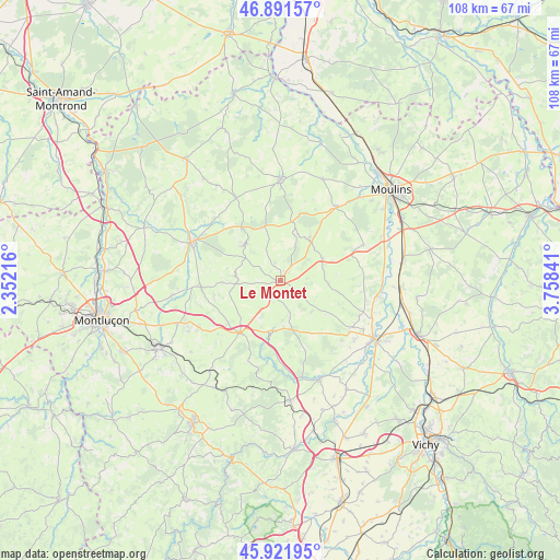
Le Montet GPS coordinates[2]
46° 24' 32.076" North, 3° 3' 19.008" East
| Map corner | latitude | longitude |
|---|---|---|
| Upper-left | 46.89157°, | 2.35216° |
| Center: | 46.40891°, | 3.05528° |
| Lower-right: | 45.92195°, | 3.75841° |
| Map W x H: | 107.8×107.8 km | = 67×67mi |
| max Lat: | 51.07786° ⇑60.9% North |
| Le Montet: | 46.40891° |
| min Lat: | ⇓39.1% South 41.3874° |
| min Long | Le Montet | max Long |
| -5.08615° | 3.05528° | 9.52242° |
| W 58.6%⇐ | ⇒41.4% E |
Elevation
Elevation of Le Montet is 475 m = 1558 ft, and this is 281.3 m = 923 ft above average elevation for this country.
| Max E: |
2333 m = 7654 ft | 8% |
| Le Montet | 475 m 1558 ft | |
| Avg. | 193.7 m = 635 ft | |
Min E: |
-1 m = -3 ft | 92% |
See also: France elevation on elevation.city.
Geographical zone
Le Montet is located in North temperate zone (between Tropic of Cancer and the Arctic Circle). Distance of this North polar circle is 2241 km =1392.5 mi to North.| Distance of | km | miles | from Le Montet |
|---|---|---|---|
| North Pole | 4846.9 | 3011.7 | to North |
| Arctic Circle | 2241 | 1392.5 | to North |
| Tropic Cancer | 2554.3 | 1587.2 | to South |
| Equator | 5160.2 | 3206.4 | to South |


Nearby cities:
15 places around Le Montet: (largest is in red/bold)
• Besson
17.4 km =10.8 mi,  67°
67°
• Bourbon-l’Archambault
19.4 km =12.1 mi,  0°
0°
• Bransat
16.5 km =10.3 mi,  125°
125°
• Buxières-les-Mines
9.8 km =6.1 mi,  312°
312°
• Bézenet
18.4 km =11.4 mi,  241°
241°
• Châtel-de-Neuvre
19.7 km =12.2 mi,  90°
90°
• Cressanges
9.1 km =5.7 mi,  62°
62°
• Montmarault
12.8 km =8 mi,  217°
217°
• Noyant-d’Allier
9.4 km =5.8 mi,  33°
33°
• Saint-Hilaire
9.9 km =6.2 mi,  344°
344°
• Saulcet
18.4 km =11.4 mi,  120°
120°
• Souvigny
17.5 km =10.9 mi,  36°
36°
• Tronget
1.8 km =1.1 mi, 32°
• Villefranche-d’Allier
15.3 km =9.5 mi,  264°
264°
• Ygrande
18.1 km =11.2 mi,  331°
331°
Sources, notices
• [Note1] Compared only with cities in France existing in our database
• [Src1] Map data: © OpenStreetMap contributors (CC-BY-SA)
• [Src2] Other city data from geonames.org with taken over terms of usage.
• [Src3] Geographical zone / Annual Mean Temperature by Robert A. Rohde @ Wikipedia
