Garches geodata
Garches (Île-de-France) is a populated place; located in France in Europe/Paris (GMT+2) time zone. With population of 18,930 people, there are 492 cities with bigger population in this country. Compared to other cities in France, 76.4% of cities are located further ↓South; 54.7% of cities are located further →East and 50.6% of cities have lower elevation than Garches. Note1
Administrative division(s):
- Level 1: Île-de-France
- Level 2: Hauts-de-Seine
- Level 3: Arrondissement de Nanterre
- Level 4: Garches


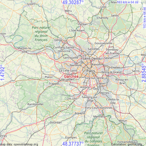
Garches GPS coordinates[2]
48° 50' 32.136" North, 2° 10' 56.352" East
| Map corner | latitude | longitude |
|---|---|---|
| Upper-left | 49.30287°, | 1.4792° |
| Center: | 48.84226°, | 2.18232° |
| Lower-right: | 48.37737°, | 2.88545° |
| Map W x H: | 102.9×102.9 km | = 63.9×63.9mi |
| max Lat: | 51.07786° ⇑23.6% North |
| Garches: | 48.84226° |
| min Lat: | ⇓76.4% South 41.3874° |
| min Long | Garches | max Long |
| -5.08615° | 2.18232° | 9.52242° |
| W 45.3%⇐ | ⇒54.7% E |
Elevation
Elevation of Garches is 134 m = 440 ft, and this is 59.7 m = 196 ft below average elevation for this country.
| Max E: |
2333 m = 7654 ft | 49.4% |
| Avg. | 193.7 m = 635 ft | |
| Garches | 134 m = 440 ft | |
Min E: |
-1 m = -3 ft | 50.6% |
See also: France elevation on elevation.city.
Geographical zone
Garches is located in North temperate zone (between Tropic of Cancer and the Arctic Circle). Distance of this North polar circle is 1970.4 km =1224.3 mi to North.| Distance of | km | miles | from Garches |
|---|---|---|---|
| North Pole | 4576.3 | 2843.6 | to North |
| Arctic Circle | 1970.4 | 1224.3 | to North |
| Tropic Cancer | 2824.8 | 1755.2 | to South |
| Equator | 5430.8 | 3374.5 | to South |


Nearby cities:
15 places around Garches: (largest is in red/bold)
• Bougival
3.7 km =2.3 mi,  306°
306°
• Boulogne-Billancourt
4.4 km =2.7 mi,  99°
99°
• Chaville
4.1 km =2.5 mi,  173°
173°
• Croissy-sur-Seine
5.2 km =3.2 mi,  321°
321°
• La Celle-Saint-Cloud
2.9 km =1.8 mi,  288°
288°
• Le Chesnay
4.9 km =3 mi,  243°
243°
• Marnes-la-Coquette
1.8 km =1.1 mi,  205°
205°
• Meudon
5 km =3.1 mi,  129°
129°
• Rueil-Malmaison
3.8 km =2.4 mi,  8°
8°
• Saint-Cloud
1.6 km =1 mi,  74°
74°
• Suresnes
4.7 km =2.9 mi,  46°
46°
• Sèvres
3.4 km =2.1 mi, 129°
• Vaucresson
1.9 km =1.2 mi,  265°
265°
• Ville-d’Avray
2.2 km =1.4 mi,  159°
159°
• Viroflay
4.9 km =3 mi,  198°
198°
Sources, notices
• [Note1] Compared only with cities in France existing in our database
• [Src1] Map data: © OpenStreetMap contributors (CC-BY-SA)
• [Src2] Other city data from geonames.org with taken over terms of usage.
• [Src3] Geographical zone / Annual Mean Temperature by Robert A. Rohde @ Wikipedia
