Vimoutiers geodata
Vimoutiers (Normandy) is a populated place; located in France in Europe/Paris (GMT+2) time zone. With population of 3,964 people, there are 2484 cities with bigger population in this country. Compared to other cities in France, 78.1% of cities are located further ↓South; 76.3% of cities are located further →East and 60.8% of cities have higher elevation than Vimoutiers. Note1
Administrative division(s):
- Level 1: Normandy
- Level 2: Département de l'Orne
- Level 3: Arrondissement de Mortagne-au-Perche
- Level 4: Vimoutiers


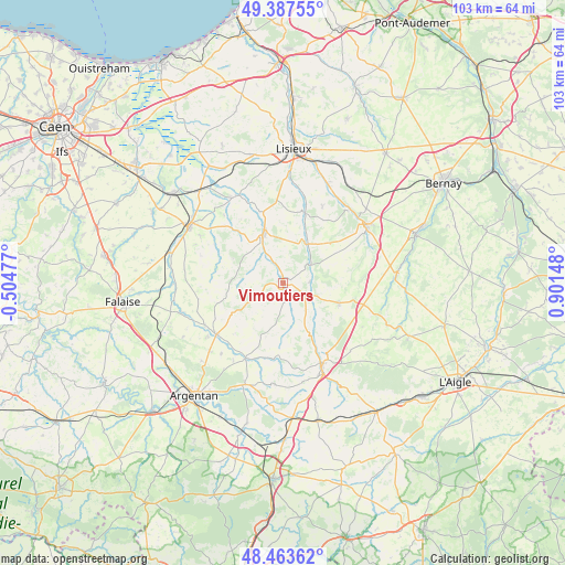
Vimoutiers GPS coordinates[2]
48° 55' 39.792" North, 0° 11' 54.06" East
| Map corner | latitude | longitude |
|---|---|---|
| Upper-left | 49.38755°, | -0.50477° |
| Center: | 48.92772°, | 0.19835° |
| Lower-right: | 48.46362°, | 0.90148° |
| Map W x H: | 102.7×102.7 km | = 63.8×63.8mi |
| max Lat: | 51.07786° ⇑21.9% North |
| Vimoutiers: | 48.92772° |
| min Lat: | ⇓78.1% South 41.3874° |
| min Long | Vimoutiers | max Long |
| -5.08615° | 0.19835° | 9.52242° |
| W 23.7%⇐ | ⇒76.3% E |
Elevation
Elevation of Vimoutiers is 100 m = 328 ft, and this is 93.7 m = 307 ft below average elevation for this country.
| Max E: |
2333 m = 7654 ft | 60.8% |
| Avg. | 193.7 m = 635 ft | |
| Vimoutiers | 100 m = 328 ft | |
Min E: |
-1 m = -3 ft | 39.2% |
See also: France elevation on elevation.city.
Geographical zone
Vimoutiers is located in North temperate zone (between Tropic of Cancer and the Arctic Circle). Distance of this North polar circle is 1960.9 km =1218.4 mi to North.| Distance of | km | miles | from Vimoutiers |
|---|---|---|---|
| North Pole | 4566.8 | 2837.7 | to North |
| Arctic Circle | 1960.9 | 1218.4 | to North |
| Tropic Cancer | 2834.3 | 1761.2 | to South |
| Equator | 5440.3 | 3380.4 | to South |


Nearby cities:
15 places around Vimoutiers: (largest is in red/bold)
• Fervaques
13.2 km =8.2 mi,  17°
17°
• Gacé
16.6 km =10.3 mi,  154°
154°
• La Chapelle-Yvon
18.3 km =11.4 mi,  34°
34°
• La Vespière
18.7 km =11.6 mi,  56°
56°
• Le Sap
10.9 km =6.8 mi,  109°
109°
• Livarot
9.3 km =5.8 mi,  337°
337°
• Morteaux-Coulibœuf
19.4 km =12.1 mi,  271°
271°
• Notre-Dame-de-Fresnay
12 km =7.5 mi,  288°
288°
• Orbec
18.8 km =11.7 mi, 58°
• Saint-Cyr-du-Ronceray
15.7 km =9.8 mi, 27°
• Saint-Germain-de-Livet
16.5 km =10.3 mi,  0°
0°
• Saint-Julien-le-Faucon
17.9 km =11.1 mi,  332°
332°
• Saint-Martin-de-Mailloc
19.8 km =12.3 mi, 22°
• Saint-Pierre-sur-Dives
19.6 km =12.2 mi,  300°
300°
• Trun
15.4 km =9.6 mi,  232°
232°
Sources, notices
• [Note1] Compared only with cities in France existing in our database
• [Src1] Map data: © OpenStreetMap contributors (CC-BY-SA)
• [Src2] Other city data from geonames.org with taken over terms of usage.
• [Src3] Geographical zone / Annual Mean Temperature by Robert A. Rohde @ Wikipedia
