Notre-Dame-de-Fresnay geodata
Notre-Dame-de-Fresnay (Normandy) is a seat of a fourth-order administrative division; located in France in Europe/Paris (GMT+2) time zone. In our database, there are 15246 cities with bigger population. Compared to other cities in France, 78.8% of cities are located further ↓South; 77.8% of cities are located further →East and 74.1% of cities have higher elevation than Notre-Dame-de-Fresnay. Note1
Administrative division(s):
- Level 1: Normandy
- Level 2: Calvados
- Level 3: Arrondissement de Lisieux
- Level 4: Saint-Pierre-en-Auge
Current local time in Notre-Dame-de-Fresnay:
07:07 PM, SaturdayDifference from your time zone: hours


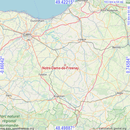
Notre-Dame-de-Fresnay GPS coordinates[2]
48° 57' 45.54" North, 0° 2' 33.756" East
| Map corner | latitude | longitude |
|---|---|---|
| Upper-left | 49.42215°, | -0.66042° |
| Center: | 48.96265°, | 0.04271° |
| Lower-right: | 48.49887°, | 0.74584° |
| Map W x H: | 102.7×102.7 km | = 63.8×63.8mi |
| max Lat: | 51.07786° ⇑21.2% North |
| Notre-Dame-de-Fresnay: | 48.96265° |
| min Lat: | ⇓78.8% South 41.3874° |
| min Long | Notre-Dame-de-F | max Long |
| -5.08615° | 0.04271° | 9.52242° |
| W 22.2%⇐ | ⇒77.8% E |
Elevation
Elevation of Notre-Dame-de-Fresnay is 69 m = 226 ft, and this is 124.7 m = 409 ft below average elevation for this country.
| Max E: |
2333 m = 7654 ft | 74.1% |
| Avg. | 193.7 m = 635 ft | |
| Notre-Dame-de-Fresnay | 69 m = 226 ft | |
Min E: |
-1 m = -3 ft | 25.9% |
See also: France elevation on elevation.city.
Geographical zone
Notre-Dame-de-Fresnay is located in North temperate zone (between Tropic of Cancer and the Arctic Circle). Distance of this North polar circle is 1957 km =1216 mi to North.| Distance of | km | miles | from Notre-Dame-de-Fresnay |
|---|---|---|---|
| North Pole | 4562.9 | 2835.3 | to North |
| Arctic Circle | 1957 | 1216 | to North |
| Tropic Cancer | 2838.2 | 1763.6 | to South |
| Equator | 5444.1 | 3382.8 | to South |


Nearby cities:
15 places around Notre-Dame-de-Fresnay: (largest is in red/bold)
• Bailleul
18.3 km =11.4 mi,  190°
190°
• Canon
15.8 km =9.8 mi,  321°
321°
• Crevecoeur-en-Auge
17.2 km =10.7 mi,  353°
353°
• Fervaques
17.7 km =11 mi,  60°
60°
• La Hoguette
17.8 km =11.1 mi,  237°
237°
• Le Mesnil-Mauger
13.6 km =8.5 mi, 351°
• Livarot
9.1 km =5.7 mi, 59°
• Magny-la-Campagne
14.3 km =8.9 mi,  311°
311°
• Morteaux-Coulibœuf
8.6 km =5.3 mi,  247°
247°
• Saint-Germain-de-Livet
17.1 km =10.6 mi,  42°
42°
• Saint-Julien-le-Faucon
12.3 km =7.6 mi,  14°
14°
• Saint-Pierre-sur-Dives
8.2 km =5.1 mi, 317°
• Trun
13.4 km =8.3 mi,  183°
183°
• Vendeuvre
9.1 km =5.7 mi,  289°
289°
• Vimoutiers
12 km =7.5 mi,  108°
108°
Sources, notices
• [Note1] Compared only with cities in France existing in our database
• [Src1] Map data: © OpenStreetMap contributors (CC-BY-SA)
• [Src2] Other city data from geonames.org with taken over terms of usage.
• [Src3] Geographical zone / Annual Mean Temperature by Robert A. Rohde @ Wikipedia
