Béceleuf geodata
Béceleuf (Nouvelle-Aquitaine) is a populated place; located in France in Europe/Paris (GMT+2) time zone. With population of 620 people, there are 12983 cities with bigger population in this country. Compared to other cities in France, 60.4% of cities are located further ↑North; 83.5% of cities are located further →East and 61.5% of cities have higher elevation than Béceleuf. Note1
Administrative division(s):
- Level 1: Nouvelle-Aquitaine
- Level 2: Département des Deux-Sèvres
- Level 3: Arrondissement de Parthenay
- Level 4: Béceleuf


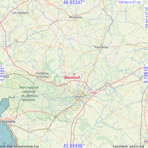
Béceleuf GPS coordinates[2]
46° 28' 16.932" North, 0° 30' 25.092" West
| Map corner | latitude | longitude |
|---|---|---|
| Upper-left | 46.95347°, | -1.2101° |
| Center: | 46.47137°, | -0.50697° |
| Lower-right: | 45.98496°, | 0.19616° |
| Map W x H: | 107.7×107.7 km | = 66.9×66.9mi |
| max Lat: | 51.07786° ⇑60.4% North |
| Béceleuf: | 46.47137° |
| min Lat: | ⇓39.6% South 41.3874° |
| min Long | Béceleuf | max Long |
| -5.08615° | -0.50697° | 9.52242° |
| W 16.5%⇐ | ⇒83.5% E |
Elevation
Elevation of Béceleuf is 98 m = 322 ft, and this is 95.7 m = 314 ft below average elevation for this country.
| Max E: |
2333 m = 7654 ft | 61.5% |
| Avg. | 193.7 m = 635 ft | |
| Béceleuf | 98 m = 322 ft | |
Min E: |
-1 m = -3 ft | 38.5% |
See also: France elevation on elevation.city.
Geographical zone
Béceleuf is located in North temperate zone (between Tropic of Cancer and the Arctic Circle). Distance of this North polar circle is 2234 km =1388.1 mi to North.| Distance of | km | miles | from Béceleuf |
|---|---|---|---|
| North Pole | 4839.9 | 3007.4 | to North |
| Arctic Circle | 2234 | 1388.1 | to North |
| Tropic Cancer | 2561.2 | 1591.5 | to South |
| Equator | 5167.1 | 3210.7 | to South |


Nearby cities:
15 places around Béceleuf: (largest is in red/bold)
• Ardin
3.9 km =2.4 mi,  274°
274°
• Benet
13.1 km =8.1 mi,  210°
210°
• Champdeniers-Saint-Denis
8.3 km =5.2 mi,  80°
80°
• Cherveux
13 km =8.1 mi,  118°
118°
• Coulonges-sur-l’Autize
7.2 km =4.5 mi,  280°
280°
• Germond-Rouvre
7.3 km =4.5 mi,  108°
108°
• Saint-Hilaire-des-Loges
12 km =7.5 mi, 270°
• Saint-Maxire
8.3 km =5.2 mi,  164°
164°
• Saint-Pompain
7.9 km =4.9 mi,  244°
244°
• Saint-Rémy
11.3 km =7 mi,  187°
187°
• Sainte-Ouenne
5.6 km =3.5 mi, 122°
• Sciecq
11.3 km =7 mi,  165°
165°
• Surin
3.5 km =2.2 mi, 109°
• Villiers-en-Plaine
7.3 km =4.5 mi,  198°
198°
• Échiré
11.5 km =7.1 mi,  142°
142°
Sources, notices
• [Note1] Compared only with cities in France existing in our database
• [Src1] Map data: © OpenStreetMap contributors (CC-BY-SA)
• [Src2] Other city data from geonames.org with taken over terms of usage.
• [Src3] Geographical zone / Annual Mean Temperature by Robert A. Rohde @ Wikipedia
