Brassac geodata
Brassac (Occitanie) is a populated place; located in France in Europe/Paris (GMT+2) time zone. With population of 1,431 people, there are 6477 cities with bigger population in this country. Compared to other cities in France, 91.5% of cities are located further ↑North; 50.6% of cities are located further ←West and 92.5% of cities have lower elevation than Brassac. Note1
Administrative division(s):
- Level 1: Occitanie
- Level 2: Tarn
- Level 3: Arrondissement de Castres
- Level 4: Brassac


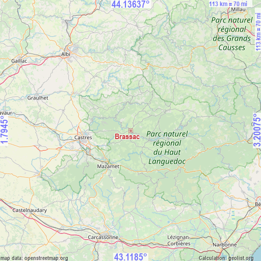
Brassac GPS coordinates[2]
43° 37' 46.524" North, 2° 29' 51.468" East
| Map corner | latitude | longitude |
|---|---|---|
| Upper-left | 44.13637°, | 1.7945° |
| Center: | 43.62959°, | 2.49763° |
| Lower-right: | 43.1185°, | 3.20075° |
| Map W x H: | 113.2×113.2 km | = 70.3×70.3mi |
| max Lat: | 51.07786° ⇑91.5% North |
| Brassac: | 43.62959° |
| min Lat: | ⇓8.5% South 41.3874° |
| min Long | Brassac | max Long |
| -5.08615° | 2.49763° | 9.52242° |
| W 50.6%⇐ | ⇒49.4% E |
Elevation
Elevation of Brassac is 490 m = 1608 ft, and this is 296.3 m = 972 ft above average elevation for this country.
| Max E: |
2333 m = 7654 ft | 7.5% |
| Brassac | 490 m 1608 ft | |
| Avg. | 193.7 m = 635 ft | |
Min E: |
-1 m = -3 ft | 92.5% |
See also: France elevation on elevation.city.
Geographical zone
Brassac is located in North temperate zone (between Tropic of Cancer and the Arctic Circle). Distance of this Northern Tropic circle is 2245.2 km =1395.1 mi to South.| Distance of | km | miles | from Brassac |
|---|---|---|---|
| North Pole | 5155.9 | 3203.7 | to North |
| Arctic Circle | 2550 | 1584.5 | to North |
| Tropic Cancer | 2245.2 | 1395.1 | to South |
| Equator | 4851.2 | 3014.4 | to South |


Nearby cities:
15 places around Brassac: (largest is in red/bold)
• Anglès
9 km =5.6 mi,  145°
145°
• Bout-du-Pont-de-Larn
16.1 km =10 mi,  203°
203°
• Burlats
14.4 km =8.9 mi,  272°
272°
• Castelnau-de-Brassac
2.6 km =1.6 mi,  35°
35°
• Lacrouzette
12.5 km =7.8 mi,  285°
285°
• Le Bez
3.2 km =2 mi,  213°
213°
• Noailhac
13.2 km =8.2 mi,  241°
241°
• Payrin-Augmontel
14.9 km =9.3 mi,  230°
230°
• Pont-de-Larn
15.7 km =9.8 mi, 207°
• Saint-Amans-Valtoret
16.6 km =10.3 mi,  181°
181°
• Saint-Pierre-de-Trivisy
15.5 km =9.6 mi,  340°
340°
• Saint-Salvy-de-la-Balme
8.2 km =5.1 mi,  255°
255°
• Vabre
9.1 km =5.7 mi,  319°
319°
• Valdurenque
16.8 km =10.4 mi,  246°
246°
• Viane
13.8 km =8.6 mi,  30°
30°
Sources, notices
• [Note1] Compared only with cities in France existing in our database
• [Src1] Map data: © OpenStreetMap contributors (CC-BY-SA)
• [Src2] Other city data from geonames.org with taken over terms of usage.
• [Src3] Geographical zone / Annual Mean Temperature by Robert A. Rohde @ Wikipedia
