Lacrouzette geodata
Lacrouzette (Occitanie) is a populated place; located in France in Europe/Paris (GMT+2) time zone. With population of 1,814 people, there are 5227 cities with bigger population in this country. Compared to other cities in France, 91.1% of cities are located further ↑North; 51.9% of cities are located further →East and 93.4% of cities have lower elevation than Lacrouzette. Note1
Administrative division(s):
- Level 1: Occitanie
- Level 2: Tarn
- Level 3: Arrondissement de Castres
- Level 4: Lacrouzette


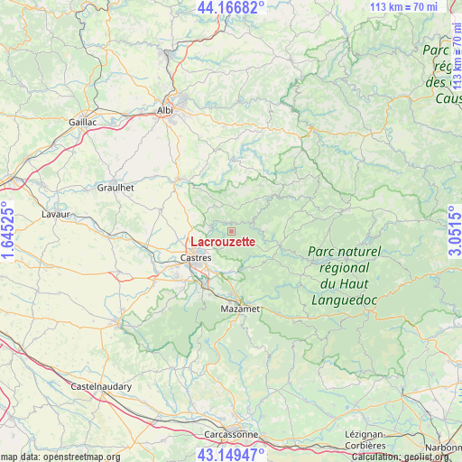
Lacrouzette GPS coordinates[2]
43° 39' 37.08" North, 2° 20' 54.168" East
| Map corner | latitude | longitude |
|---|---|---|
| Upper-left | 44.16682°, | 1.64525° |
| Center: | 43.6603°, | 2.34838° |
| Lower-right: | 43.14947°, | 3.0515° |
| Map W x H: | 113.1×113.1 km | = 70.3×70.3mi |
| max Lat: | 51.07786° ⇑91.1% North |
| Lacrouzette: | 43.6603° |
| min Lat: | ⇓8.9% South 41.3874° |
| min Long | Lacrouzette | max Long |
| -5.08615° | 2.34838° | 9.52242° |
| W 48.1%⇐ | ⇒51.9% E |
Elevation
Elevation of Lacrouzette is 518 m = 1699 ft, and this is 324.3 m = 1064 ft above average elevation for this country.
| Max E: |
2333 m = 7654 ft | 6.6% |
| Lacrouzette | 518 m 1699 ft | |
| Avg. | 193.7 m = 635 ft | |
Min E: |
-1 m = -3 ft | 93.4% |
See also: France elevation on elevation.city.
Geographical zone
Lacrouzette is located in North temperate zone (between Tropic of Cancer and the Arctic Circle). Distance of this Northern Tropic circle is 2248.7 km =1397.3 mi to South.| Distance of | km | miles | from Lacrouzette |
|---|---|---|---|
| North Pole | 5152.5 | 3201.6 | to North |
| Arctic Circle | 2546.6 | 1582.4 | to North |
| Tropic Cancer | 2248.7 | 1397.3 | to South |
| Equator | 4854.6 | 3016.5 | to South |


Nearby cities:
15 places around Lacrouzette: (largest is in red/bold)
• Brassac
12.5 km =7.8 mi,  105°
105°
• Burlats
3.6 km =2.2 mi,  221°
221°
• Castelnau-de-Brassac
13.6 km =8.5 mi,  95°
95°
• Castres
10.6 km =6.6 mi,  235°
235°
• Lagarrigue
10.8 km =6.7 mi,  211°
211°
• Le Bez
11.9 km =7.4 mi,  120°
120°
• Montredon-Labessonnié
6.6 km =4.1 mi,  343°
343°
• Navès
14.5 km =9 mi, 222°
• Noailhac
9.7 km =6 mi,  177°
177°
• Payrin-Augmontel
12.9 km =8 mi, 177°
• Roquecourbe
4.5 km =2.8 mi,  275°
275°
• Saint-Pierre-de-Trivisy
13.2 km =8.2 mi,  31°
31°
• Saint-Salvy-de-la-Balme
6.8 km =4.2 mi,  143°
143°
• Vabre
7.1 km =4.4 mi,  60°
60°
• Valdurenque
10.6 km =6.6 mi,  198°
198°
Sources, notices
• [Note1] Compared only with cities in France existing in our database
• [Src1] Map data: © OpenStreetMap contributors (CC-BY-SA)
• [Src2] Other city data from geonames.org with taken over terms of usage.
• [Src3] Geographical zone / Annual Mean Temperature by Robert A. Rohde @ Wikipedia
