Vescemont geodata
Vescemont (Bourgogne-Franche-Comté) is a populated place; located in France in Europe/Paris (GMT+2) time zone. With population of 753 people, there are 11137 cities with bigger population in this country. Compared to other cities in France, 54.9% of cities are located further ↓South; 93.9% of cities are located further ←West and 93.9% of cities have lower elevation than Vescemont. Note1
Administrative division(s):
- Level 1: Bourgogne-Franche-Comté
- Level 2: Territoire de Belfort
- Level 3: Arrondissement de Belfort
- Level 4: Vescemont


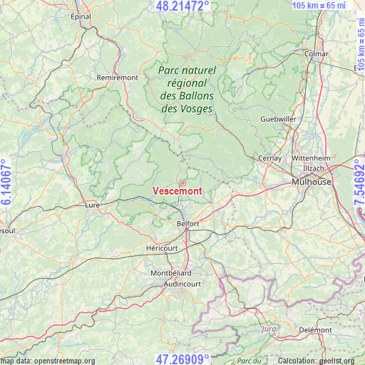
Vescemont GPS coordinates[2]
47° 44' 38.58" North, 6° 50' 37.68" East
| Map corner | latitude | longitude |
|---|---|---|
| Upper-left | 48.21472°, | 6.14067° |
| Center: | 47.74405°, | 6.8438° |
| Lower-right: | 47.26909°, | 7.54692° |
| Map W x H: | 105.1×105.1 km | = 65.3×65.3mi |
| max Lat: | 51.07786° ⇑45.1% North |
| Vescemont: | 47.74405° |
| min Lat: | ⇓54.9% South 41.3874° |
| min Long | Vescemont | max Long |
| -5.08615° | 6.8438° | 9.52242° |
| W 93.9%⇐ | ⇒6.1% E |
Elevation
Elevation of Vescemont is 539 m = 1768 ft, and this is 345.3 m = 1133 ft above average elevation for this country.
| Max E: |
2333 m = 7654 ft | 6.1% |
| Vescemont | 539 m 1768 ft | |
| Avg. | 193.7 m = 635 ft | |
Min E: |
-1 m = -3 ft | 93.9% |
See also: France elevation on elevation.city.
Geographical zone
Vescemont is located in North temperate zone (between Tropic of Cancer and the Arctic Circle). Distance of this North polar circle is 2092.5 km =1300.2 mi to North.| Distance of | km | miles | from Vescemont |
|---|---|---|---|
| North Pole | 4698.4 | 2919.4 | to North |
| Arctic Circle | 2092.5 | 1300.2 | to North |
| Tropic Cancer | 2702.7 | 1679.4 | to South |
| Equator | 5308.6 | 3298.6 | to South |


Nearby cities:
15 places around Vescemont: (largest is in red/bold)
• Anjoutey
8.2 km =5.1 mi,  125°
125°
• Chaux
3.3 km =2.1 mi,  191°
191°
• Giromagny
1.2 km =0.7 mi,  263°
263°
• Grosmagny
3.9 km =2.4 mi, 126°
• Lachapelle-sous-Chaux
4.7 km =2.9 mi,  201°
201°
• Lepuix
2.9 km =1.8 mi,  309°
309°
• Plancher-Bas
8.9 km =5.5 mi,  252°
252°
• Plancher-les-Mines
7.8 km =4.8 mi,  284°
284°
• Rougegoutte
1.3 km =0.8 mi,  157°
157°
• Rougemont-le-Château
9.3 km =5.8 mi,  96°
96°
• Salbert
8.6 km =5.3 mi, 195°
• Sermamagny
5.9 km =3.7 mi, 185°
• Sewen
8.4 km =5.2 mi,  33°
33°
• Valdoie
8.2 km =5.1 mi,  180°
180°
• Éloie
6.4 km =4 mi, 159°
Sources, notices
• [Note1] Compared only with cities in France existing in our database
• [Src1] Map data: © OpenStreetMap contributors (CC-BY-SA)
• [Src2] Other city data from geonames.org with taken over terms of usage.
• [Src3] Geographical zone / Annual Mean Temperature by Robert A. Rohde @ Wikipedia
