Grosmagny geodata
Grosmagny (Bourgogne-Franche-Comté) is a populated place; located in France in Europe/Paris (GMT+2) time zone. With population of 502 people, there are 15200 cities with bigger population in this country. Compared to other cities in France, 54.6% of cities are located further ↓South; 94.2% of cities are located further ←West and 92.2% of cities have lower elevation than Grosmagny. Note1
Administrative division(s):
- Level 1: Bourgogne-Franche-Comté
- Level 2: Territoire de Belfort
- Level 3: Arrondissement de Belfort
- Level 4: Grosmagny


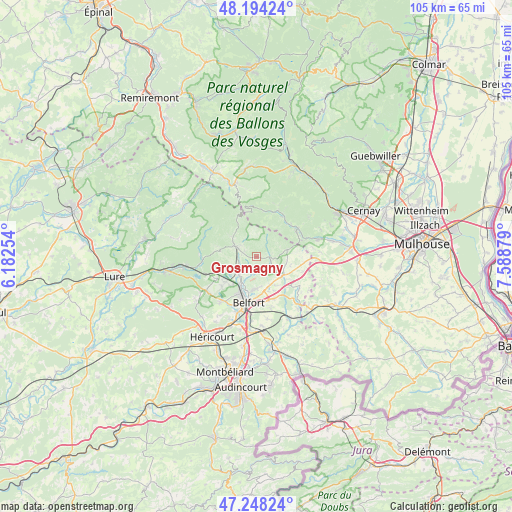
Grosmagny GPS coordinates[2]
47° 43' 24.204" North, 6° 53' 8.376" East
| Map corner | latitude | longitude |
|---|---|---|
| Upper-left | 48.19424°, | 6.18254° |
| Center: | 47.72339°, | 6.88566° |
| Lower-right: | 47.24824°, | 7.58879° |
| Map W x H: | 105.2×105.2 km | = 65.4×65.4mi |
| max Lat: | 51.07786° ⇑45.4% North |
| Grosmagny: | 47.72339° |
| min Lat: | ⇓54.6% South 41.3874° |
| min Long | Grosmagny | max Long |
| -5.08615° | 6.88566° | 9.52242° |
| W 94.2%⇐ | ⇒5.8% E |
Elevation
Elevation of Grosmagny is 481 m = 1578 ft, and this is 287.3 m = 943 ft above average elevation for this country.
| Max E: |
2333 m = 7654 ft | 7.8% |
| Grosmagny | 481 m 1578 ft | |
| Avg. | 193.7 m = 635 ft | |
Min E: |
-1 m = -3 ft | 92.2% |
See also: France elevation on elevation.city.
Geographical zone
Grosmagny is located in North temperate zone (between Tropic of Cancer and the Arctic Circle). Distance of this North polar circle is 2094.8 km =1301.6 mi to North.| Distance of | km | miles | from Grosmagny |
|---|---|---|---|
| North Pole | 4700.7 | 2920.9 | to North |
| Arctic Circle | 2094.8 | 1301.6 | to North |
| Tropic Cancer | 2700.4 | 1678 | to South |
| Equator | 5306.3 | 3297.2 | to South |


Nearby cities:
15 places around Grosmagny: (largest is in red/bold)
• Anjoutey
4.3 km =2.7 mi,  125°
125°
• Chaux
3.9 km =2.4 mi,  256°
256°
• Denney
7.5 km =4.7 mi,  161°
161°
• Giromagny
4.9 km =3 mi,  296°
296°
• Lachapelle-sous-Chaux
5.3 km =3.3 mi,  247°
247°
• Lepuix
6.7 km =4.2 mi,  307°
307°
• Offemont
6.8 km =4.2 mi,  185°
185°
• Roppe
6.5 km =4 mi, 157°
• Rougegoutte
2.9 km =1.8 mi,  292°
292°
• Rougemont-le-Château
6.2 km =3.9 mi,  77°
77°
• Saint-Germain-le-Châtelet
6.2 km =3.9 mi,  117°
117°
• Sermamagny
5.1 km =3.2 mi,  225°
225°
• Valdoie
6.7 km =4.2 mi,  208°
208°
• Vescemont
3.9 km =2.4 mi, 306°
• Éloie
3.8 km =2.4 mi, 193°
Sources, notices
• [Note1] Compared only with cities in France existing in our database
• [Src1] Map data: © OpenStreetMap contributors (CC-BY-SA)
• [Src2] Other city data from geonames.org with taken over terms of usage.
• [Src3] Geographical zone / Annual Mean Temperature by Robert A. Rohde @ Wikipedia
