Bocé geodata
Bocé (Pays de la Loire) is a populated place; located in France in Europe/Paris (GMT+2) time zone. With population of 532 people, there are 14567 cities with bigger population in this country. Compared to other cities in France, 51.3% of cities are located further ↓South; 78.8% of cities are located further →East and 75.8% of cities have higher elevation than Bocé. Note1
Administrative division(s):
- Level 1: Pays de la Loire
- Level 2: Département de Maine-et-Loire
- Level 3: Arrondissement de Saumur
- Level 4: Baugé-en-Anjou


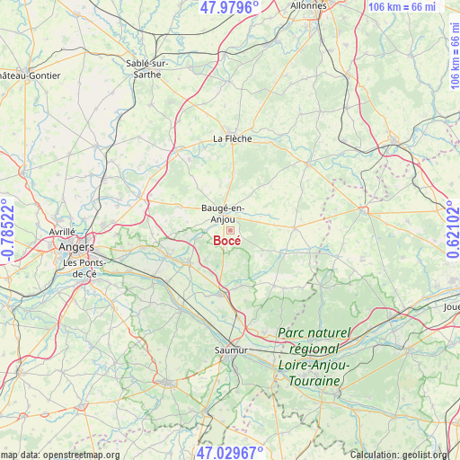
Bocé GPS coordinates[2]
47° 30' 24.408" North, 0° 4' 55.56" West
| Map corner | latitude | longitude |
|---|---|---|
| Upper-left | 47.9796°, | -0.78522° |
| Center: | 47.50678°, | -0.0821° |
| Lower-right: | 47.02967°, | 0.62102° |
| Map W x H: | 105.6×105.6 km | = 65.6×65.6mi |
| max Lat: | 51.07786° ⇑48.7% North |
| Bocé: | 47.50678° |
| min Lat: | ⇓51.3% South 41.3874° |
| min Long | Bocé | max Long |
| -5.08615° | -0.0821° | 9.52242° |
| W 21.2%⇐ | ⇒78.8% E |
Elevation
Elevation of Bocé is 65 m = 213 ft, and this is 128.7 m = 422 ft below average elevation for this country.
| Max E: |
2333 m = 7654 ft | 75.8% |
| Avg. | 193.7 m = 635 ft | |
| Bocé | 65 m = 213 ft | |
Min E: |
-1 m = -3 ft | 24.2% |
See also: France elevation on elevation.city.
Geographical zone
Bocé is located in North temperate zone (between Tropic of Cancer and the Arctic Circle). Distance of this North polar circle is 2118.9 km =1316.6 mi to North.| Distance of | km | miles | from Bocé |
|---|---|---|---|
| North Pole | 4724.8 | 2935.9 | to North |
| Arctic Circle | 2118.9 | 1316.6 | to North |
| Tropic Cancer | 2676.3 | 1663 | to South |
| Equator | 5282.3 | 3282.3 | to South |


Nearby cities:
15 places around Bocé: (largest is in red/bold)
• Baugé-en-Anjou
4.6 km =2.9 mi,  336°
336°
• Beaufort-en-Vallée
12.7 km =7.9 mi,  234°
234°
• Brion
9.2 km =5.7 mi,  217°
217°
• Cheviré-le-Rouge
12.3 km =7.6 mi,  322°
322°
• Clefs-Val d'Anjou
13.2 km =8.2 mi,  3°
3°
• Fontaine-Guérin
8.3 km =5.2 mi,  254°
254°
• Fougeré
14.4 km =8.9 mi, 339°
• Jarzé
12.5 km =7.8 mi,  295°
295°
• Jumelles
8.1 km =5 mi,  191°
191°
• Le Vieil-Baugé
3.9 km =2.4 mi, 315°
• Mazé
15.3 km =9.5 mi, 248°
• Mouliherne
8.7 km =5.4 mi,  120°
120°
• Noyant
15 km =9.3 mi,  88°
88°
• Saint-Philbert-du-Peuple
13 km =8.1 mi,  167°
167°
• Vernantes
16.2 km =10.1 mi,  141°
141°
Sources, notices
• [Note1] Compared only with cities in France existing in our database
• [Src1] Map data: © OpenStreetMap contributors (CC-BY-SA)
• [Src2] Other city data from geonames.org with taken over terms of usage.
• [Src3] Geographical zone / Annual Mean Temperature by Robert A. Rohde @ Wikipedia
