Cuinchy geodata
Cuinchy (Hauts-de-France) is a populated place; located in France in Europe/Paris (GMT+2) time zone. With population of 1,696 people, there are 5531 cities with bigger population in this country. Compared to other cities in France, 97.5% of cities are located further ↓South; 54.2% of cities are located further ←West and 93.1% of cities have higher elevation than Cuinchy. Note1
Administrative division(s):
- Level 1: Hauts-de-France
- Level 2: Pas-de-Calais
- Level 3: Arrondissement de Béthune
- Level 4: Cuinchy


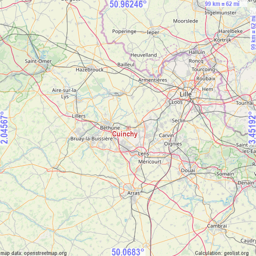
Cuinchy GPS coordinates[2]
50° 31' 3" North, 2° 44' 55.68" East
| Map corner | latitude | longitude |
|---|---|---|
| Upper-left | 50.96246°, | 2.04567° |
| Center: | 50.5175°, | 2.7488° |
| Lower-right: | 50.0683°, | 3.45192° |
| Map W x H: | 99.4×99.4 km | = 61.8×61.8mi |
| max Lat: | 51.07786° ⇑2.5% North |
| Cuinchy: | 50.5175° |
| min Lat: | ⇓97.5% South 41.3874° |
| min Long | Cuinchy | max Long |
| -5.08615° | 2.7488° | 9.52242° |
| W 54.2%⇐ | ⇒45.8% E |
Elevation
Elevation of Cuinchy is 22 m = 72 ft, and this is 171.7 m = 563 ft below average elevation for this country.
| Max E: |
2333 m = 7654 ft | 93.1% |
| Avg. | 193.7 m = 635 ft | |
| Cuinchy | 22 m = 72 ft | |
Min E: |
-1 m = -3 ft | 6.9% |
See also: France elevation on elevation.city.
Geographical zone
Cuinchy is located in North temperate zone (between Tropic of Cancer and the Arctic Circle). Distance of this North polar circle is 1784.2 km =1108.7 mi to North.| Distance of | km | miles | from Cuinchy |
|---|---|---|---|
| North Pole | 4390 | 2727.8 | to North |
| Arctic Circle | 1784.2 | 1108.7 | to North |
| Tropic Cancer | 3011.1 | 1871 | to South |
| Equator | 5617 | 3490.2 | to South |


Nearby cities:
15 places around Cuinchy: (largest is in red/bold)
• Annequin
2.4 km =1.5 mi,  236°
236°
• Auchy-les-Mines
2.4 km =1.5 mi,  100°
100°
• Beuvry
4.5 km =2.8 mi,  268°
268°
• Cambrin
1 km =0.6 mi,  213°
213°
• Festubert
2.9 km =1.8 mi,  341°
341°
• Haisnes
3.4 km =2.1 mi,  108°
108°
• Hulluch
5.5 km =3.4 mi,  124°
124°
• La Bassée
4.5 km =2.8 mi,  65°
65°
• Labourse
5.2 km =3.2 mi,  246°
246°
• Mazingarbe
5.7 km =3.5 mi,  204°
204°
• Noyelles-lès-Vermelles
3.4 km =2.1 mi, 207°
• Richebourg-l'Avoué
5.8 km =3.6 mi,  0°
0°
• Sailly-Labourse
4.1 km =2.5 mi, 243°
• Vermelles
3.1 km =1.9 mi,  181°
181°
• Violaines
3.9 km =2.4 mi,  46°
46°
Sources, notices
• [Note1] Compared only with cities in France existing in our database
• [Src1] Map data: © OpenStreetMap contributors (CC-BY-SA)
• [Src2] Other city data from geonames.org with taken over terms of usage.
• [Src3] Geographical zone / Annual Mean Temperature by Robert A. Rohde @ Wikipedia
