Veaugues geodata
Veaugues (Centre) is a populated place; located in France in Europe/Paris (GMT+2) time zone. With population of 625 people, there are 12901 cities with bigger population in this country. Compared to other cities in France, 52.2% of cities are located further ↑North; 54.3% of cities are located further ←West and 68.1% of cities have lower elevation than Veaugues. Note1
Administrative division(s):
- Level 1: Centre
- Level 2: Cher
- Level 3: Arrondissement de Bourges
- Level 4: Veaugues


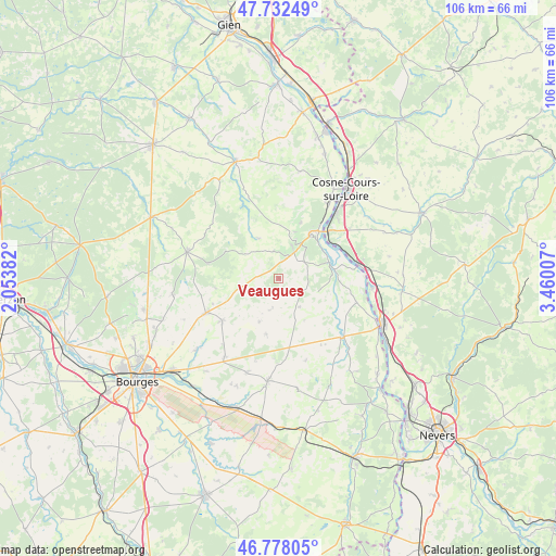
Veaugues GPS coordinates[2]
47° 15' 26.712" North, 2° 45' 25.02" East
| Map corner | latitude | longitude |
|---|---|---|
| Upper-left | 47.73249°, | 2.05382° |
| Center: | 47.25742°, | 2.75695° |
| Lower-right: | 46.77805°, | 3.46007° |
| Map W x H: | 106.1×106.1 km | = 65.9×65.9mi |
| max Lat: | 51.07786° ⇑52.2% North |
| Veaugues: | 47.25742° |
| min Lat: | ⇓47.8% South 41.3874° |
| min Long | Veaugues | max Long |
| -5.08615° | 2.75695° | 9.52242° |
| W 54.3%⇐ | ⇒45.7% E |
Elevation
Elevation of Veaugues is 210 m = 689 ft, and this is 16.3 m = 53 ft above average elevation for this country.
| Max E: |
2333 m = 7654 ft | 31.9% |
| Veaugues | 210 m 689 ft | |
| Avg. | 193.7 m = 635 ft | |
Min E: |
-1 m = -3 ft | 68.1% |
See also: France elevation on elevation.city.
Geographical zone
Veaugues is located in North temperate zone (between Tropic of Cancer and the Arctic Circle). Distance of this North polar circle is 2146.6 km =1333.8 mi to North.| Distance of | km | miles | from Veaugues |
|---|---|---|---|
| North Pole | 4752.5 | 2953.1 | to North |
| Arctic Circle | 2146.6 | 1333.8 | to North |
| Tropic Cancer | 2648.6 | 1645.8 | to South |
| Equator | 5254.5 | 3265 | to South |


Nearby cities:
15 places around Veaugues: (largest is in red/bold)
• Bannay
17.4 km =10.8 mi,  33°
33°
• Brécy
18.1 km =11.2 mi,  214°
214°
• Crézancy-en-Sancerre
4.8 km =3 mi,  353°
353°
• Herry
15.5 km =9.6 mi,  106°
106°
• Jars
16.4 km =10.2 mi,  339°
339°
• Les Aix-d’Angillon
16 km =9.9 mi,  244°
244°
• Mesves-sur-Loire
17.8 km =11.1 mi,  95°
95°
• Pouilly-sur-Loire
15.2 km =9.4 mi,  78°
78°
• Rians
13.9 km =8.6 mi,  231°
231°
• Saint-Andelain
16.4 km =10.2 mi,  69°
69°
• Saint-Satur
10.9 km =6.8 mi, 33°
• Sancergues
16.5 km =10.3 mi,  134°
134°
• Sancerre
9.9 km =6.2 mi,  36°
36°
• Sury-en-Vaux
12.8 km =8 mi,  16°
16°
• Tracy-sur-Loire
12.1 km =7.5 mi,  54°
54°
Sources, notices
• [Note1] Compared only with cities in France existing in our database
• [Src1] Map data: © OpenStreetMap contributors (CC-BY-SA)
• [Src2] Other city data from geonames.org with taken over terms of usage.
• [Src3] Geographical zone / Annual Mean Temperature by Robert A. Rohde @ Wikipedia
