Sancerre geodata
Sancerre (Centre) is a populated place; located in France in Europe/Paris (GMT+2) time zone. With population of 1,839 people, there are 5152 cities with bigger population in this country. Compared to other cities in France, 51.1% of cities are located further ↑North; 55.5% of cities are located further ←West and 75.4% of cities have lower elevation than Sancerre. Note1
Administrative division(s):
- Level 1: Centre
- Level 2: Cher
- Level 3: Arrondissement de Bourges
- Level 4: Sancerre


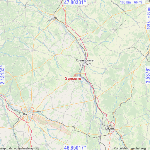
Sancerre GPS coordinates[2]
47° 19' 44.004" North, 2° 50' 4.092" East
| Map corner | latitude | longitude |
|---|---|---|
| Upper-left | 47.80331°, | 2.13135° |
| Center: | 47.32889°, | 2.83447° |
| Lower-right: | 46.85017°, | 3.5376° |
| Map W x H: | 106×106 km | = 65.9×65.9mi |
| max Lat: | 51.07786° ⇑51.1% North |
| Sancerre: | 47.32889° |
| min Lat: | ⇓48.9% South 41.3874° |
| min Long | Sancerre | max Long |
| -5.08615° | 2.83447° | 9.52242° |
| W 55.5%⇐ | ⇒44.5% E |
Elevation
Elevation of Sancerre is 252 m = 827 ft, and this is 58.3 m = 191 ft above average elevation for this country.
| Max E: |
2333 m = 7654 ft | 24.6% |
| Sancerre | 252 m 827 ft | |
| Avg. | 193.7 m = 635 ft | |
Min E: |
-1 m = -3 ft | 75.4% |
See also: France elevation on elevation.city.
Geographical zone
Sancerre is located in North temperate zone (between Tropic of Cancer and the Arctic Circle). Distance of this North polar circle is 2138.7 km =1328.9 mi to North.| Distance of | km | miles | from Sancerre |
|---|---|---|---|
| North Pole | 4744.6 | 2948.2 | to North |
| Arctic Circle | 2138.7 | 1328.9 | to North |
| Tropic Cancer | 2656.6 | 1650.7 | to South |
| Equator | 5262.5 | 3270 | to South |


Nearby cities:
15 places around Sancerre: (largest is in red/bold)
• Bannay
7.5 km =4.7 mi,  29°
29°
• Boulleret
11 km =6.8 mi,  15°
15°
• Cosne-Cours-sur-Loire
11.4 km =7.1 mi,  36°
36°
• Crézancy-en-Sancerre
7.1 km =4.4 mi,  243°
243°
• Herry
15.4 km =9.6 mi,  144°
144°
• Jars
13.7 km =8.5 mi,  302°
302°
• Mesves-sur-Loire
15.3 km =9.5 mi,  128°
128°
• Myennes
15 km =9.3 mi, 29°
• Pouilly-sur-Loire
10.3 km =6.4 mi,  119°
119°
• Saint-Andelain
9.8 km =6.1 mi,  103°
103°
• Saint-Satur
1.2 km =0.7 mi,  10°
10°
• Savigny-en-Sancerre
12.7 km =7.9 mi,  351°
351°
• Sury-en-Vaux
4.9 km =3 mi,  332°
332°
• Tracy-sur-Loire
4.1 km =2.5 mi, 103°
• Veaugues
9.9 km =6.2 mi,  216°
216°
Sources, notices
• [Note1] Compared only with cities in France existing in our database
• [Src1] Map data: © OpenStreetMap contributors (CC-BY-SA)
• [Src2] Other city data from geonames.org with taken over terms of usage.
• [Src3] Geographical zone / Annual Mean Temperature by Robert A. Rohde @ Wikipedia
