Malemort-sur-Corrèze geodata
Malemort-sur-Corrèze (Nouvelle-Aquitaine) is a populated place; located in France in Europe/Paris (GMT+2) time zone. With population of 7,124 people, there are 1368 cities with bigger population in this country. Compared to other cities in France, 77.8% of cities are located further ↑North; 62.2% of cities are located further →East and 55.2% of cities have higher elevation than Malemort-sur-Corrèze. Note1
Administrative division(s):
- Level 1: Nouvelle-Aquitaine
- Level 2: Département de la Corrèze
- Level 3: Arrondissement de Brive-la-Gaillarde
- Level 4: Malemort


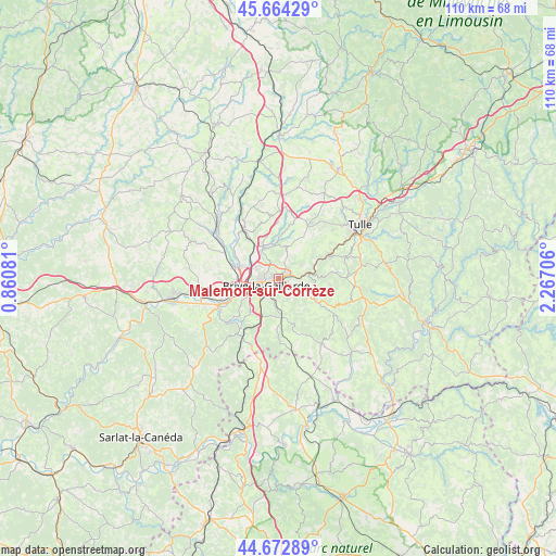
Malemort-sur-Corrèze GPS coordinates[2]
45° 10' 14.7" North, 1° 33' 50.148" East
| Map corner | latitude | longitude |
|---|---|---|
| Upper-left | 45.66429°, | 0.86081° |
| Center: | 45.17075°, | 1.56393° |
| Lower-right: | 44.67289°, | 2.26706° |
| Map W x H: | 110.2×110.2 km | = 68.5×68.5mi |
| max Lat: | 51.07786° ⇑77.8% North |
| Malemort-sur-Corrèze: | 45.17075° |
| min Lat: | ⇓22.2% South 41.3874° |
| min Long | Malemort-sur-Co | max Long |
| -5.08615° | 1.56393° | 9.52242° |
| W 37.8%⇐ | ⇒62.2% E |
Elevation
Elevation of Malemort-sur-Corrèze is 116 m = 381 ft, and this is 77.7 m = 255 ft below average elevation for this country.
| Max E: |
2333 m = 7654 ft | 55.2% |
| Avg. | 193.7 m = 635 ft | |
| Malemort-sur-Corrèze | 116 m = 381 ft | |
Min E: |
-1 m = -3 ft | 44.8% |
See also: France elevation on elevation.city.
Geographical zone
Malemort-sur-Corrèze is located in North temperate zone (between Tropic of Cancer and the Arctic Circle). Distance of this North polar circle is 2378.7 km =1478.1 mi to North.| Distance of | km | miles | from Malemort-sur-Corrèze |
|---|---|---|---|
| North Pole | 4984.5 | 3097.2 | to North |
| Arctic Circle | 2378.7 | 1478.1 | to North |
| Tropic Cancer | 2416.6 | 1501.6 | to South |
| Equator | 5022.5 | 3120.8 | to South |


Nearby cities:
15 places around Malemort-sur-Corrèze: (largest is in red/bold)
• Aubazine
8.6 km =5.3 mi,  86°
86°
• Brive-la-Gaillarde
2.7 km =1.7 mi,  241°
241°
• Cornil
11 km =6.8 mi,  66°
66°
• Cosnac
4.4 km =2.7 mi,  157°
157°
• Dampniat
5.3 km =3.3 mi, 93°
• Donzenac
7 km =4.3 mi,  333°
333°
• Jugeals-Nazareth
9.9 km =6.2 mi,  182°
182°
• Lissac-sur-Couze
10.9 km =6.8 mi,  227°
227°
• Noailles
8.2 km =5.1 mi,  203°
203°
• Saint-Hilaire-Peyroux
8.2 km =5.1 mi,  54°
54°
• Saint-Pantaléon-de-Larche
9.8 km =6.1 mi,  250°
250°
• Saint-Viance
10.2 km =6.3 mi,  300°
300°
• Sainte-Féréole
6.7 km =4.2 mi,  12°
12°
• Ussac
4.7 km =2.9 mi, 302°
• Varetz
9.2 km =5.7 mi,  286°
286°
Sources, notices
• [Note1] Compared only with cities in France existing in our database
• [Src1] Map data: © OpenStreetMap contributors (CC-BY-SA)
• [Src2] Other city data from geonames.org with taken over terms of usage.
• [Src3] Geographical zone / Annual Mean Temperature by Robert A. Rohde @ Wikipedia
