Brive-la-Gaillarde geodata
Brive-la-Gaillarde (Nouvelle-Aquitaine) is a seat of a third-order administrative division; located in France in Europe/Paris (GMT+2) time zone. With population of 53,466 people, there are 105 cities with bigger population in this country. Compared to other cities in France, 77.9% of cities are located further ↑North; 62.6% of cities are located further →East and 56.9% of cities have higher elevation than Brive-la-Gaillarde. Note1
Administrative division(s):
- Level 1: Nouvelle-Aquitaine
- Level 2: Département de la Corrèze
- Level 3: Arrondissement de Brive-la-Gaillarde
- Level 4: Brive-la-Gaillarde


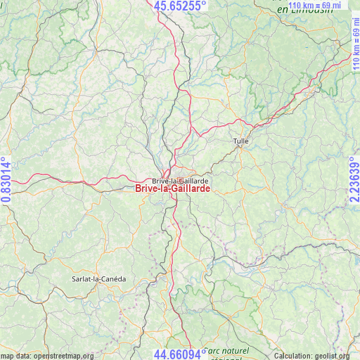
Brive-la-Gaillarde GPS coordinates[2]
45° 9' 32.04" North, 1° 31' 59.736" East
| Map corner | latitude | longitude |
|---|---|---|
| Upper-left | 45.65255°, | 0.83014° |
| Center: | 45.1589°, | 1.53326° |
| Lower-right: | 44.66094°, | 2.23639° |
| Map W x H: | 110.3×110.3 km | = 68.5×68.5mi |
| max Lat: | 51.07786° ⇑77.9% North |
| Brive-la-Gaillarde: | 45.1589° |
| min Lat: | ⇓22.1% South 41.3874° |
| min Long | Brive-la-Gailla | max Long |
| -5.08615° | 1.53326° | 9.52242° |
| W 37.4%⇐ | ⇒62.6% E |
Elevation
Elevation of Brive-la-Gaillarde is 111 m = 364 ft, and this is 82.7 m = 271 ft below average elevation for this country.
| Max E: |
2333 m = 7654 ft | 56.9% |
| Avg. | 193.7 m = 635 ft | |
| Brive-la-Gaillarde | 111 m = 364 ft | |
Min E: |
-1 m = -3 ft | 43.1% |
See also: Brive-la-Gaillarde elevation on elevation.city.
Geographical zone
Brive-la-Gaillarde is located in North temperate zone (between Tropic of Cancer and the Arctic Circle). Distance of this North polar circle is 2380 km =1478.9 mi to North.| Distance of | km | miles | from Brive-la-Gaillarde |
|---|---|---|---|
| North Pole | 4985.9 | 3098.1 | to North |
| Arctic Circle | 2380 | 1478.9 | to North |
| Tropic Cancer | 2415.3 | 1500.8 | to South |
| Equator | 5021.2 | 3120 | to South |


Nearby cities:
15 places around Brive-la-Gaillarde: (largest is in red/bold)
• Chasteaux
9 km =5.6 mi,  214°
214°
• Cosnac
4.9 km =3 mi,  123°
123°
• Dampniat
7.8 km =4.8 mi,  82°
82°
• Donzenac
7.6 km =4.7 mi,  354°
354°
• Jugeals-Nazareth
8.9 km =5.5 mi,  166°
166°
• Larche
10.2 km =6.3 mi,  245°
245°
• Lissac-sur-Couze
8.3 km =5.2 mi,  222°
222°
• Malemort-sur-Corrèze
2.7 km =1.7 mi,  61°
61°
• Noailles
6.3 km =3.9 mi,  187°
187°
• Saint-Hilaire-Peyroux
10.9 km =6.8 mi, 55°
• Saint-Pantaléon-de-Larche
7.1 km =4.4 mi, 253°
• Saint-Viance
9.1 km =5.7 mi,  315°
315°
• Sainte-Féréole
8.7 km =5.4 mi,  26°
26°
• Ussac
4.2 km =2.6 mi,  338°
338°
• Varetz
7.6 km =4.7 mi,  301°
301°
Sources, notices
• [Note1] Compared only with cities in France existing in our database
• [Src1] Map data: © OpenStreetMap contributors (CC-BY-SA)
• [Src2] Other city data from geonames.org with taken over terms of usage.
• [Src3] Geographical zone / Annual Mean Temperature by Robert A. Rohde @ Wikipedia
