Turny geodata
Turny (Bourgogne-Franche-Comté) is a populated place; located in France in Europe/Paris (GMT+2) time zone. With population of 839 people, there are 10196 cities with bigger population in this country. Compared to other cities in France, 59.9% of cities are located further ↓South; 66% of cities are located further ←West and 53.3% of cities have higher elevation than Turny. Note1
Administrative division(s):
- Level 1: Bourgogne-Franche-Comté
- Level 2: Département de l'Yonne
- Level 3: Auxerre
- Level 4: Turny


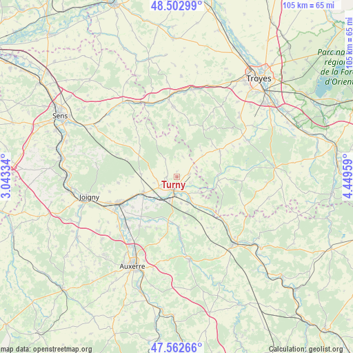
Turny GPS coordinates[2]
48° 2' 5.892" North, 3° 44' 47.292" East
| Map corner | latitude | longitude |
|---|---|---|
| Upper-left | 48.50299°, | 3.04334° |
| Center: | 48.03497°, | 3.74647° |
| Lower-right: | 47.56266°, | 4.44959° |
| Map W x H: | 104.6×104.6 km | = 65×65mi |
| max Lat: | 51.07786° ⇑40.1% North |
| Turny: | 48.03497° |
| min Lat: | ⇓59.9% South 41.3874° |
| min Long | Turny | max Long |
| -5.08615° | 3.74647° | 9.52242° |
| W 66%⇐ | ⇒34% E |
Elevation
Elevation of Turny is 121 m = 397 ft, and this is 72.7 m = 239 ft below average elevation for this country.
| Max E: |
2333 m = 7654 ft | 53.3% |
| Avg. | 193.7 m = 635 ft | |
| Turny | 121 m = 397 ft | |
Min E: |
-1 m = -3 ft | 46.7% |
See also: France elevation on elevation.city.
Geographical zone
Turny is located in North temperate zone (between Tropic of Cancer and the Arctic Circle). Distance of this North polar circle is 2060.2 km =1280.1 mi to North.| Distance of | km | miles | from Turny |
|---|---|---|---|
| North Pole | 4666.1 | 2899.4 | to North |
| Arctic Circle | 2060.2 | 1280.1 | to North |
| Tropic Cancer | 2735.1 | 1699.5 | to South |
| Equator | 5341 | 3318.7 | to South |


Nearby cities:
15 places around Turny: (largest is in red/bold)
• Arces-Dilo
12.1 km =7.5 mi,  296°
296°
• Auxon
14.9 km =9.3 mi,  58°
58°
• Brienon-sur-Armançon
10.9 km =6.8 mi,  242°
242°
• Chailley
6.3 km =3.9 mi,  327°
327°
• Champlost
5.8 km =3.6 mi,  258°
258°
• Chessy-les-Prés
12.6 km =7.8 mi,  95°
95°
• Ervy-le-Châtel
12.2 km =7.6 mi,  86°
86°
• Flogny-la-Chapelle
13 km =8.1 mi,  136°
136°
• Germigny
5.1 km =3.2 mi,  149°
149°
• Mont-Saint-Sulpice
12.7 km =7.9 mi,  224°
224°
• Neuvy-Sautour
3.7 km =2.3 mi,  77°
77°
• Pontigny
14.6 km =9.1 mi,  190°
190°
• Saint-Florentin
4.1 km =2.5 mi,  202°
202°
• Venizy
2.7 km =1.7 mi,  269°
269°
• Vergigny
7.5 km =4.7 mi, 196°
Sources, notices
• [Note1] Compared only with cities in France existing in our database
• [Src1] Map data: © OpenStreetMap contributors (CC-BY-SA)
• [Src2] Other city data from geonames.org with taken over terms of usage.
• [Src3] Geographical zone / Annual Mean Temperature by Robert A. Rohde @ Wikipedia
