Chailley geodata
Chailley (Bourgogne-Franche-Comté) is a populated place; located in France in Europe/Paris (GMT+2) time zone. With population of 639 people, there are 12686 cities with bigger population in this country. Compared to other cities in France, 60.8% of cities are located further ↓South; 65.7% of cities are located further ←West and 58.7% of cities have lower elevation than Chailley. Note1
Administrative division(s):
- Level 1: Bourgogne-Franche-Comté
- Level 2: Département de l'Yonne
- Level 3: Auxerre
- Level 4: Chailley


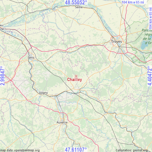
Chailley GPS coordinates[2]
48° 4' 58.584" North, 3° 42' 5.724" East
| Map corner | latitude | longitude |
|---|---|---|
| Upper-left | 48.55052°, | 2.99847° |
| Center: | 48.08294°, | 3.70159° |
| Lower-right: | 47.61107°, | 4.40472° |
| Map W x H: | 104.5×104.5 km | = 64.9×64.9mi |
| max Lat: | 51.07786° ⇑39.2% North |
| Chailley: | 48.08294° |
| min Lat: | ⇓60.8% South 41.3874° |
| min Long | Chailley | max Long |
| -5.08615° | 3.70159° | 9.52242° |
| W 65.7%⇐ | ⇒34.3% E |
Elevation
Elevation of Chailley is 164 m = 538 ft, and this is 29.7 m = 97 ft below average elevation for this country.
| Max E: |
2333 m = 7654 ft | 41.3% |
| Avg. | 193.7 m = 635 ft | |
| Chailley | 164 m = 538 ft | |
Min E: |
-1 m = -3 ft | 58.7% |
See also: France elevation on elevation.city.
Geographical zone
Chailley is located in North temperate zone (between Tropic of Cancer and the Arctic Circle). Distance of this North polar circle is 2054.9 km =1276.9 mi to North.| Distance of | km | miles | from Chailley |
|---|---|---|---|
| North Pole | 4660.7 | 2896 | to North |
| Arctic Circle | 2054.9 | 1276.9 | to North |
| Tropic Cancer | 2740.4 | 1702.8 | to South |
| Equator | 5346.3 | 3322 | to South |


Nearby cities:
15 places around Chailley: (largest is in red/bold)
• Aix-en-Othe
15.9 km =9.9 mi,  8°
8°
• Arces-Dilo
7.5 km =4.7 mi,  270°
270°
• Auxon
16.2 km =10.1 mi,  81°
81°
• Brienon-sur-Armançon
12.1 km =7.5 mi,  211°
211°
• Bussy-en-Othe
15.6 km =9.7 mi,  243°
243°
• Champlost
6.9 km =4.3 mi,  200°
200°
• Ervy-le-Châtel
16.2 km =10.1 mi,  106°
106°
• Germigny
11.4 km =7.1 mi,  148°
148°
• Mont-Saint-Sulpice
15.5 km =9.6 mi, 201°
• Neuvy-Sautour
8.3 km =5.2 mi,  123°
123°
• Saint-Florentin
9.3 km =5.8 mi,  169°
169°
• Saint-Mards-en-Othe
12.3 km =7.6 mi,  35°
35°
• Turny
6.3 km =3.9 mi, 147°
• Venizy
5.4 km =3.4 mi, 173°
• Vergigny
12.6 km =7.8 mi, 174°
Sources, notices
• [Note1] Compared only with cities in France existing in our database
• [Src1] Map data: © OpenStreetMap contributors (CC-BY-SA)
• [Src2] Other city data from geonames.org with taken over terms of usage.
• [Src3] Geographical zone / Annual Mean Temperature by Robert A. Rohde @ Wikipedia
