Ervy-le-Châtel geodata
Ervy-le-Châtel (Grand Est) is a populated place; located in France in Europe/Paris (GMT+2) time zone. With population of 1,200 people, there are 7535 cities with bigger population in this country. Compared to other cities in France, 60.1% of cities are located further ↓South; 67% of cities are located further ←West and 56.6% of cities have lower elevation than Ervy-le-Châtel. Note1
Administrative division(s):
- Level 1: Grand Est
- Level 2: Département de l'Aube
- Level 3: Arrondissement de Troyes
- Level 4: Ervy-le-Châtel


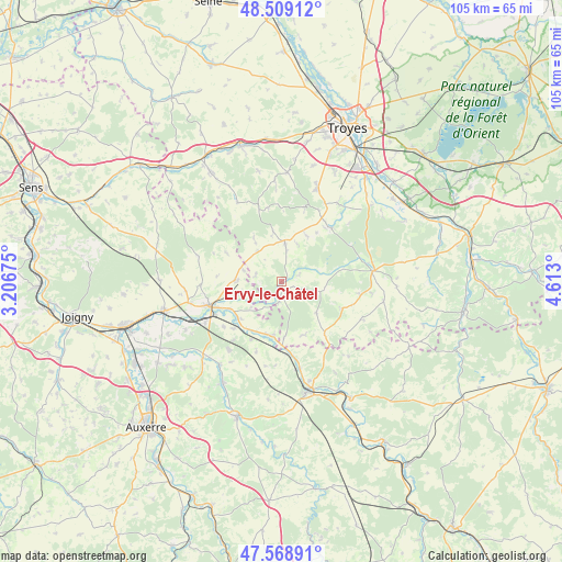
Ervy-le-Châtel GPS coordinates[2]
48° 2' 28.176" North, 3° 54' 35.568" East
| Map corner | latitude | longitude |
|---|---|---|
| Upper-left | 48.50912°, | 3.20675° |
| Center: | 48.04116°, | 3.90988° |
| Lower-right: | 47.56891°, | 4.613° |
| Map W x H: | 104.5×104.5 km | = 64.9×64.9mi |
| max Lat: | 51.07786° ⇑39.9% North |
| Ervy-le-Châtel: | 48.04116° |
| min Lat: | ⇓60.1% South 41.3874° |
| min Long | Ervy-le-Châtel | max Long |
| -5.08615° | 3.90988° | 9.52242° |
| W 67%⇐ | ⇒33% E |
Elevation
Elevation of Ervy-le-Châtel is 156 m = 512 ft, and this is 37.7 m = 124 ft below average elevation for this country.
| Max E: |
2333 m = 7654 ft | 43.4% |
| Avg. | 193.7 m = 635 ft | |
| Ervy-le-Châtel | 156 m = 512 ft | |
Min E: |
-1 m = -3 ft | 56.6% |
See also: France elevation on elevation.city.
Geographical zone
Ervy-le-Châtel is located in North temperate zone (between Tropic of Cancer and the Arctic Circle). Distance of this North polar circle is 2059.5 km =1279.7 mi to North.| Distance of | km | miles | from Ervy-le-Châtel |
|---|---|---|---|
| North Pole | 4665.4 | 2898.9 | to North |
| Arctic Circle | 2059.5 | 1279.7 | to North |
| Tropic Cancer | 2735.8 | 1699.9 | to South |
| Equator | 5341.7 | 3319.2 | to South |


Nearby cities:
15 places around Ervy-le-Châtel: (largest is in red/bold)
• Auxon
7.1 km =4.4 mi,  4°
4°
• Bouilly
18.6 km =11.6 mi,  21°
21°
• Chailley
16.2 km =10.1 mi,  286°
286°
• Champlost
17.9 km =11.1 mi,  264°
264°
• Chaource
17 km =10.6 mi,  83°
83°
• Chessy-les-Prés
2 km =1.2 mi,  168°
168°
• Flogny-la-Chapelle
10.6 km =6.6 mi,  197°
197°
• Germigny
10.9 km =6.8 mi,  241°
241°
• Ligny-le-Châtel
19.3 km =12 mi,  215°
215°
• Neuvy-Sautour
8.6 km =5.3 mi,  270°
270°
• Saint-Florentin
14.5 km =9 mi,  251°
251°
• Saint-Mards-en-Othe
16.8 km =10.4 mi,  330°
330°
• Turny
12.2 km =7.6 mi, 266°
• Venizy
14.9 km =9.3 mi, 267°
• Vergigny
16.2 km =10.1 mi, 241°
Sources, notices
• [Note1] Compared only with cities in France existing in our database
• [Src1] Map data: © OpenStreetMap contributors (CC-BY-SA)
• [Src2] Other city data from geonames.org with taken over terms of usage.
• [Src3] Geographical zone / Annual Mean Temperature by Robert A. Rohde @ Wikipedia
