Saclay geodata
Saclay (Île-de-France) is a populated place; located in France in Europe/Paris (GMT+2) time zone. With population of 3,048 people, there are 3191 cities with bigger population in this country. Compared to other cities in France, 73.9% of cities are located further ↓South; 54.9% of cities are located further →East and 56.3% of cities have lower elevation than Saclay. Note1
Administrative division(s):
- Level 1: Île-de-France
- Level 2: Département de l'Essonne
- Level 3: Arrondissement de Palaiseau
- Level 4: Saclay


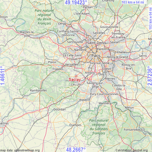
Saclay GPS coordinates[2]
48° 43' 57.36" North, 2° 10' 9.228" East
| Map corner | latitude | longitude |
|---|---|---|
| Upper-left | 49.19423°, | 1.46611° |
| Center: | 48.7326°, | 2.16923° |
| Lower-right: | 48.2667°, | 2.87236° |
| Map W x H: | 103.1×103.1 km | = 64.1×64.1mi |
| max Lat: | 51.07786° ⇑26.1% North |
| Saclay: | 48.7326° |
| min Lat: | ⇓73.9% South 41.3874° |
| min Long | Saclay | max Long |
| -5.08615° | 2.16923° | 9.52242° |
| W 45.1%⇐ | ⇒54.9% E |
Elevation
Elevation of Saclay is 155 m = 509 ft, and this is 38.7 m = 127 ft below average elevation for this country.
| Max E: |
2333 m = 7654 ft | 43.7% |
| Avg. | 193.7 m = 635 ft | |
| Saclay | 155 m = 509 ft | |
Min E: |
-1 m = -3 ft | 56.3% |
See also: France elevation on elevation.city.
Geographical zone
Saclay is located in North temperate zone (between Tropic of Cancer and the Arctic Circle). Distance of this North polar circle is 1982.6 km =1231.9 mi to North.| Distance of | km | miles | from Saclay |
|---|---|---|---|
| North Pole | 4588.5 | 2851.2 | to North |
| Arctic Circle | 1982.6 | 1231.9 | to North |
| Tropic Cancer | 2812.6 | 1747.7 | to South |
| Equator | 5418.6 | 3367 | to South |


Nearby cities:
15 places around Saclay: (largest is in red/bold)
• Bièvres
4.6 km =2.9 mi,  52°
52°
• Buc
5.8 km =3.6 mi,  326°
326°
• Bures-sur-Yvette
3.6 km =2.2 mi,  178°
178°
• Châteaufort
5.8 km =3.6 mi,  273°
273°
• Igny
4.2 km =2.6 mi,  72°
72°
• Jouy-en-Josas
2.9 km =1.8 mi,  0°
0°
• Les Loges-en-Josas
4.1 km =2.5 mi, 328°
• Les Ulis
5.7 km =3.5 mi, 179°
• Orsay
4.3 km =2.7 mi,  162°
162°
• Saint-Aubin
3 km =1.9 mi,  223°
223°
• Toussus-le-Noble
4.5 km =2.8 mi,  294°
294°
• Vauhallan
2.5 km =1.6 mi,  87°
87°
• Villebon-sur-Yvette
6 km =3.7 mi,  119°
119°
• Villiers-le-Bâcle
3.7 km =2.3 mi,  262°
262°
• Vélizy-Villacoublay
5.8 km =3.6 mi,  18°
18°
Sources, notices
• [Note1] Compared only with cities in France existing in our database
• [Src1] Map data: © OpenStreetMap contributors (CC-BY-SA)
• [Src2] Other city data from geonames.org with taken over terms of usage.
• [Src3] Geographical zone / Annual Mean Temperature by Robert A. Rohde @ Wikipedia
