Thouaré-sur-Loire geodata
Thouaré-sur-Loire (Pays de la Loire) is a populated place; located in France in Europe/Paris (GMT+2) time zone. With population of 7,172 people, there are 1357 cities with bigger population in this country. Compared to other cities in France, 52% of cities are located further ↑North; 91.8% of cities are located further →East and 96% of cities have higher elevation than Thouaré-sur-Loire. Note1
Administrative division(s):
- Level 1: Pays de la Loire
- Level 2: Loire-Atlantique
- Level 3: Arrondissement de Nantes
- Level 4: Thouaré-sur-Loire


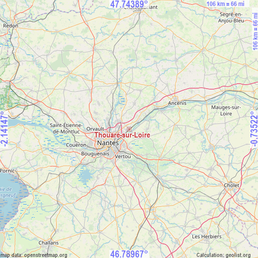
Thouaré-sur-Loire GPS coordinates[2]
47° 16' 8.148" North, 1° 26' 18.024" West
| Map corner | latitude | longitude |
|---|---|---|
| Upper-left | 47.74389°, | -2.14147° |
| Center: | 47.26893°, | -1.43834° |
| Lower-right: | 46.78967°, | -0.73522° |
| Map W x H: | 106.1×106.1 km | = 65.9×65.9mi |
| max Lat: | 51.07786° ⇑52% North |
| Thouaré-sur-Loire: | 47.26893° |
| min Lat: | ⇓48% South 41.3874° |
| min Long | Thouaré-sur-Lo | max Long |
| -5.08615° | -1.43834° | 9.52242° |
| W 8.2%⇐ | ⇒91.8% E |
Elevation
Elevation of Thouaré-sur-Loire is 14 m = 46 ft, and this is 179.7 m = 590 ft below average elevation for this country.
| Max E: |
2333 m = 7654 ft | 96% |
| Avg. | 193.7 m = 635 ft | |
| Thouaré-sur-Loire | 14 m = 46 ft | |
Min E: |
-1 m = -3 ft | 4% |
See also: France elevation on elevation.city.
Geographical zone
Thouaré-sur-Loire is located in North temperate zone (between Tropic of Cancer and the Arctic Circle). Distance of this North polar circle is 2145.4 km =1333.1 mi to North.| Distance of | km | miles | from Thouaré-sur-Loire |
|---|---|---|---|
| North Pole | 4751.2 | 2952.3 | to North |
| Arctic Circle | 2145.4 | 1333.1 | to North |
| Tropic Cancer | 2649.9 | 1646.6 | to South |
| Equator | 5255.8 | 3265.8 | to South |


Nearby cities:
15 places around Thouaré-sur-Loire: (largest is in red/bold)
• Basse-Goulaine
6.7 km =4.2 mi,  199°
199°
• Carquefou
5.1 km =3.2 mi,  309°
309°
• Haute-Goulaine
7.8 km =4.8 mi,  175°
175°
• La Chapelle-Basse-Mer
7.5 km =4.7 mi,  88°
88°
• La Chapelle-sur-Erdre
9.2 km =5.7 mi,  289°
289°
• La Varenne
10.1 km =6.3 mi,  62°
62°
• Le Cellier
9 km =5.6 mi,  50°
50°
• Le Loroux-Bottereau
7.6 km =4.7 mi,  117°
117°
• Mauves-sur-Loire
5 km =3.1 mi, 50°
• Nantes
10.4 km =6.5 mi,  236°
236°
• Saint-Julien-de-Concelles
4.5 km =2.8 mi,  113°
113°
• Saint-Mars-du-Désert
11 km =6.8 mi,  12°
12°
• Saint-Sébastien-sur-Loire
8.4 km =5.2 mi,  215°
215°
• Sainte-Luce-sur-Loire
3.9 km =2.4 mi, 244°
• Sucé-sur-Erdre
10.1 km =6.3 mi, 314°
Sources, notices
• [Note1] Compared only with cities in France existing in our database
• [Src1] Map data: © OpenStreetMap contributors (CC-BY-SA)
• [Src2] Other city data from geonames.org with taken over terms of usage.
• [Src3] Geographical zone / Annual Mean Temperature by Robert A. Rohde @ Wikipedia
