Saint-Hilaire-de-Villefranche geodata
Saint-Hilaire-de-Villefranche (Nouvelle-Aquitaine) is a populated place; located in France in Europe/Paris (GMT+2) time zone. With population of 1,127 people, there are 7965 cities with bigger population in this country. Compared to other cities in France, 68.5% of cities are located further ↑North; 83.7% of cities are located further →East and 85.3% of cities have higher elevation than Saint-Hilaire-de-Villefranche. Note1
Administrative division(s):
- Level 1: Nouvelle-Aquitaine
- Level 2: Charente-Maritime
- Level 3: Arrondissement de Saint-Jean-d'Angély
- Level 4: Saint-Hilaire-de-Villefranche
Current local time in Saint-Hilaire-de-Villefranche:
02:09 PM, SaturdayDifference from your time zone: hours


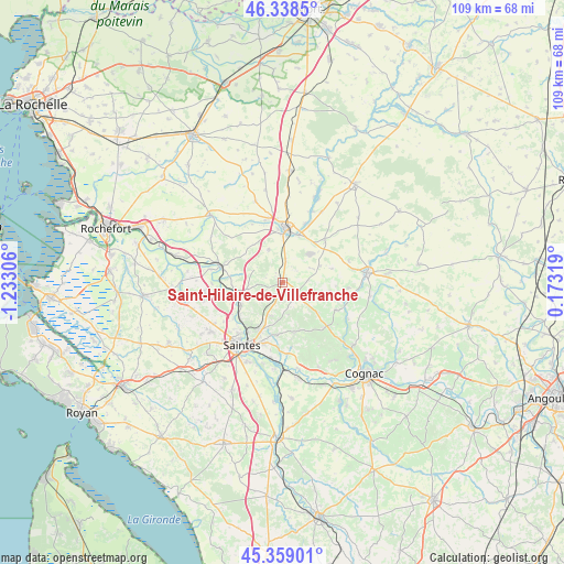
Saint-Hilaire-de-Villefranche GPS coordinates[2]
45° 51' 3.276" North, 0° 31' 47.748" West
| Map corner | latitude | longitude |
|---|---|---|
| Upper-left | 46.3385°, | -1.23306° |
| Center: | 45.85091°, | -0.52993° |
| Lower-right: | 45.35901°, | 0.17319° |
| Map W x H: | 108.9×108.9 km | = 67.7×67.7mi |
| max Lat: | 51.07786° ⇑68.5% North |
| Saint-Hilaire-de-Villefranche: | 45.85091° |
| min Lat: | ⇓31.5% South 41.3874° |
| min Long | Saint-Hilaire-d | max Long |
| -5.08615° | -0.52993° | 9.52242° |
| W 16.3%⇐ | ⇒83.7% E |
Elevation
Elevation of Saint-Hilaire-de-Villefranche is 41 m = 135 ft, and this is 152.7 m = 501 ft below average elevation for this country.
| Max E: |
2333 m = 7654 ft | 85.3% |
| Avg. | 193.7 m = 635 ft | |
| Saint-Hilaire-de-Villefranche | 41 m = 135 ft | |
Min E: |
-1 m = -3 ft | 14.7% |
See also: France elevation on elevation.city.
Geographical zone
Saint-Hilaire-de-Villefranche is located in North temperate zone (between Tropic of Cancer and the Arctic Circle). Distance of this North polar circle is 2303 km =1431 mi to North.| Distance of | km | miles | from Saint-Hilaire-de-Villefranche |
|---|---|---|---|
| North Pole | 4908.9 | 3050.2 | to North |
| Arctic Circle | 2303 | 1431 | to North |
| Tropic Cancer | 2492.2 | 1548.6 | to South |
| Equator | 5098.1 | 3167.8 | to South |


Nearby cities:
15 places around Saint-Hilaire-de-Villefranche: (largest is in red/bold)
• Asnières-la-Giraud
4.4 km =2.7 mi,  8°
8°
• Aumagne
10.1 km =6.3 mi,  74°
74°
• Brizambourg
4.9 km =3 mi,  129°
129°
• Bussac-sur-Charente
11 km =6.8 mi,  226°
226°
• Fontcouverte
10.3 km =6.4 mi,  205°
205°
• La Chapelle-des-Pots
10.2 km =6.3 mi,  184°
184°
• Le Douhet
4.3 km =2.7 mi,  221°
221°
• Mazeray
6.9 km =4.3 mi,  338°
338°
• Migron
11.7 km =7.3 mi,  117°
117°
• Saint-Jean-d’Angély
10.4 km =6.5 mi,  3°
3°
• Saint-Savinien
11.9 km =7.4 mi,  284°
284°
• Taillebourg
9.2 km =5.7 mi,  258°
258°
• Varaize
11.4 km =7.1 mi,  45°
45°
• Vénérand
6.8 km =4.2 mi,  197°
197°
• Écoyeux
3.7 km =2.3 mi,  149°
149°
Sources, notices
• [Note1] Compared only with cities in France existing in our database
• [Src1] Map data: © OpenStreetMap contributors (CC-BY-SA)
• [Src2] Other city data from geonames.org with taken over terms of usage.
• [Src3] Geographical zone / Annual Mean Temperature by Robert A. Rohde @ Wikipedia
