Magny-la-Campagne geodata
Magny-la-Campagne (Normandy) is a populated place; located in France in Europe/Paris (GMT+2) time zone. With population of 536 people, there are 14480 cities with bigger population in this country. Compared to other cities in France, 80.9% of cities are located further ↓South; 78.9% of cities are located further →East and 82.6% of cities have higher elevation than Magny-la-Campagne. Note1
Administrative division(s):
- Level 1: Normandy
- Level 2: Calvados
- Level 3: Arrondissement de Lisieux
- Level 4: Mézidon Vallée d'Auge


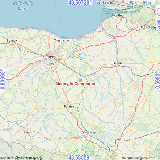
Magny-la-Campagne GPS coordinates[2]
49° 2' 54.852" North, 0° 6' 13.788" West
| Map corner | latitude | longitude |
|---|---|---|
| Upper-left | 49.50728°, | -0.80695° |
| Center: | 49.04857°, | -0.10383° |
| Lower-right: | 48.58559°, | 0.5993° |
| Map W x H: | 102.5×102.5 km | = 63.7×63.7mi |
| max Lat: | 51.07786° ⇑19.1% North |
| Magny-la-Campagne: | 49.04857° |
| min Lat: | ⇓80.9% South 41.3874° |
| min Long | Magny-la-Campag | max Long |
| -5.08615° | -0.10383° | 9.52242° |
| W 21.1%⇐ | ⇒78.9% E |
Elevation
Elevation of Magny-la-Campagne is 48 m = 157 ft, and this is 145.7 m = 478 ft below average elevation for this country.
| Max E: |
2333 m = 7654 ft | 82.6% |
| Avg. | 193.7 m = 635 ft | |
| Magny-la-Campagne | 48 m = 157 ft | |
Min E: |
-1 m = -3 ft | 17.4% |
See also: France elevation on elevation.city.
Geographical zone
Magny-la-Campagne is located in North temperate zone (between Tropic of Cancer and the Arctic Circle). Distance of this North polar circle is 1947.5 km =1210.1 mi to North.| Distance of | km | miles | from Magny-la-Campagne |
|---|---|---|---|
| North Pole | 4553.4 | 2829.4 | to North |
| Arctic Circle | 1947.5 | 1210.1 | to North |
| Tropic Cancer | 2847.8 | 1769.5 | to South |
| Equator | 5453.7 | 3388.8 | to South |


Nearby cities:
15 places around Magny-la-Campagne: (largest is in red/bold)
• Airan
6.8 km =4.2 mi,  328°
328°
• Argences
9.8 km =6.1 mi, 332°
• Bellengreville
11.4 km =7.1 mi,  317°
317°
• Canon
2.9 km =1.8 mi,  16°
16°
• Chicheboville
10.6 km =6.6 mi,  309°
309°
• Crevecoeur-en-Auge
11.6 km =7.2 mi,  49°
49°
• Le Mesnil-Mauger
9.6 km =6 mi,  65°
65°
• Moult
8.6 km =5.3 mi, 328°
• Méry-Corbon
9.8 km =6.1 mi,  9°
9°
• Ouilly-le-Tesson
11 km =6.8 mi,  231°
231°
• Saint-Pierre-sur-Dives
6.2 km =3.9 mi,  124°
124°
• Saint-Sylvain
8.3 km =5.2 mi,  275°
275°
• Soumont-Saint-Quentin
12.3 km =7.6 mi, 230°
• Vendeuvre
6.8 km =4.2 mi,  162°
162°
• Vimont
10.7 km =6.6 mi, 319°
Sources, notices
• [Note1] Compared only with cities in France existing in our database
• [Src1] Map data: © OpenStreetMap contributors (CC-BY-SA)
• [Src2] Other city data from geonames.org with taken over terms of usage.
• [Src3] Geographical zone / Annual Mean Temperature by Robert A. Rohde @ Wikipedia
