Seyssel geodata
Seyssel (Auvergne-Rhône-Alpes) is a populated place; located in France in Europe/Paris (GMT+2) time zone. With population of 918 people, there are 9502 cities with bigger population in this country. Compared to other cities in France, 66.7% of cities are located further ↑North; 85.4% of cities are located further ←West and 76.2% of cities have lower elevation than Seyssel. Note1
Administrative division(s):
- Level 1: Auvergne-Rhône-Alpes
- Level 2: Département de l'Ain
- Level 3: Arrondissement de Belley
- Level 4: Seyssel


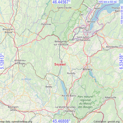
Seyssel GPS coordinates[2]
45° 57' 32.508" North, 5° 49' 52.5" East
| Map corner | latitude | longitude |
|---|---|---|
| Upper-left | 46.44567°, | 5.12813° |
| Center: | 45.95903°, | 5.83125° |
| Lower-right: | 45.46808°, | 6.53438° |
| Map W x H: | 108.7×108.7 km | = 67.5×67.5mi |
| max Lat: | 51.07786° ⇑66.7% North |
| Seyssel: | 45.95903° |
| min Lat: | ⇓33.3% South 41.3874° |
| min Long | Seyssel | max Long |
| -5.08615° | 5.83125° | 9.52242° |
| W 85.4%⇐ | ⇒14.6% E |
Elevation
Elevation of Seyssel is 258 m = 846 ft, and this is 64.3 m = 211 ft above average elevation for this country.
| Max E: |
2333 m = 7654 ft | 23.8% |
| Seyssel | 258 m 846 ft | |
| Avg. | 193.7 m = 635 ft | |
Min E: |
-1 m = -3 ft | 76.2% |
See also: France elevation on elevation.city.
Geographical zone
Seyssel is located in North temperate zone (between Tropic of Cancer and the Arctic Circle). Distance of this North polar circle is 2291 km =1423.6 mi to North.| Distance of | km | miles | from Seyssel |
|---|---|---|---|
| North Pole | 4896.9 | 3042.8 | to North |
| Arctic Circle | 2291 | 1423.6 | to North |
| Tropic Cancer | 2504.2 | 1556 | to South |
| Equator | 5110.2 | 3175.3 | to South |


Nearby cities:
15 places around Seyssel: (largest is in red/bold)
• Anglefort
5.6 km =3.5 mi,  198°
198°
• Chanay
6.3 km =3.9 mi,  324°
324°
• Chilly
10.2 km =6.3 mi,  69°
69°
• Corbonod
1.2 km =0.7 mi, 323°
• Desingy
6 km =3.7 mi,  47°
47°
• Frangy
10.3 km =6.4 mi, 49°
• Génissiat
10.6 km =6.6 mi,  347°
347°
• Menthonnex-sous-Clermont
8 km =5 mi,  86°
86°
• Moye
11.2 km =7 mi,  145°
145°
• Ruffieux
12.3 km =7.6 mi,  175°
175°
• Serrières-en-Chautagne
8.6 km =5.3 mi,  173°
173°
• Seyssel
0.4 km =0.2 mi, 88°
• Thusy
9.6 km =6 mi,  98°
98°
• Vallières
10.6 km =6.6 mi,  128°
128°
• Versonnex
8 km =5 mi,  114°
114°
Sources, notices
• [Note1] Compared only with cities in France existing in our database
• [Src1] Map data: © OpenStreetMap contributors (CC-BY-SA)
• [Src2] Other city data from geonames.org with taken over terms of usage.
• [Src3] Geographical zone / Annual Mean Temperature by Robert A. Rohde @ Wikipedia
