Seyches geodata
Seyches (Nouvelle-Aquitaine) is a populated place; located in France in Europe/Paris (GMT+2) time zone. With population of 944 people, there are 9259 cities with bigger population in this country. Compared to other cities in France, 83.2% of cities are located further ↑North; 75.3% of cities are located further →East and 76.2% of cities have higher elevation than Seyches. Note1
Administrative division(s):
- Level 1: Nouvelle-Aquitaine
- Level 2: Département du Lot-et-Garonne
- Level 3: Arrondissement de Marmande
- Level 4: Seyches


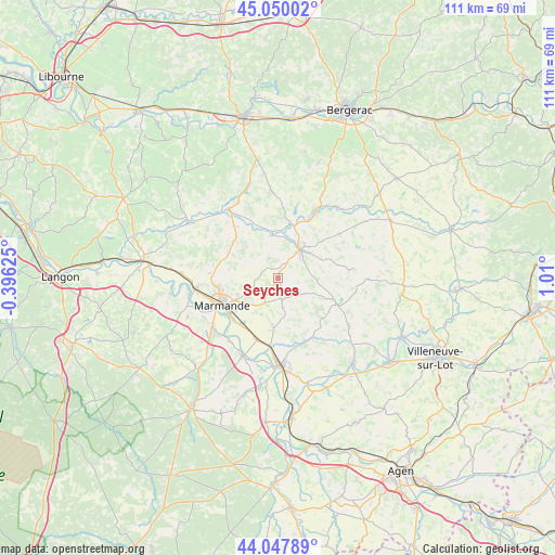
Seyches GPS coordinates[2]
44° 33' 3.996" North, 0° 18' 24.732" East
| Map corner | latitude | longitude |
|---|---|---|
| Upper-left | 45.05002°, | -0.39625° |
| Center: | 44.55111°, | 0.30687° |
| Lower-right: | 44.04789°, | 1.01° |
| Map W x H: | 111.4×111.4 km | = 69.2×69.2mi |
| max Lat: | 51.07786° ⇑83.2% North |
| Seyches: | 44.55111° |
| min Lat: | ⇓16.8% South 41.3874° |
| min Long | Seyches | max Long |
| -5.08615° | 0.30687° | 9.52242° |
| W 24.7%⇐ | ⇒75.3% E |
Elevation
Elevation of Seyches is 64 m = 210 ft, and this is 129.7 m = 426 ft below average elevation for this country.
| Max E: |
2333 m = 7654 ft | 76.2% |
| Avg. | 193.7 m = 635 ft | |
| Seyches | 64 m = 210 ft | |
Min E: |
-1 m = -3 ft | 23.8% |
See also: France elevation on elevation.city.
Geographical zone
Seyches is located in North temperate zone (between Tropic of Cancer and the Arctic Circle). Distance of this Northern Tropic circle is 2347.7 km =1458.8 mi to South.| Distance of | km | miles | from Seyches |
|---|---|---|---|
| North Pole | 5053.4 | 3140 | to North |
| Arctic Circle | 2447.6 | 1520.9 | to North |
| Tropic Cancer | 2347.7 | 1458.8 | to South |
| Equator | 4953.6 | 3078 | to South |


Nearby cities:
15 places around Seyches: (largest is in red/bold)
• Beaupuy
12.6 km =7.8 mi,  262°
262°
• Birac-sur-Trec
8 km =5 mi,  203°
203°
• Escassefort
5.4 km =3.4 mi,  266°
266°
• Fauguerolles
12.9 km =8 mi, 200°
• Fongrave
7.6 km =4.7 mi,  104°
104°
• Gontaud-de-Nogaret
11.3 km =7 mi,  182°
182°
• Lavergne
8.5 km =5.3 mi,  58°
58°
• Lévignac-de-Guyenne
12.1 km =7.5 mi,  315°
315°
• Marmande
12.6 km =7.8 mi,  243°
243°
• Miramont-de-Guyenne
7.1 km =4.4 mi,  38°
38°
• Puymiclan
4.4 km =2.7 mi,  170°
170°
• Roumagne
7.9 km =4.9 mi,  18°
18°
• Saint-Pardoux-Isaac
8.6 km =5.3 mi, 37°
• Saint-Pardoux-du-Breuil
12.2 km =7.6 mi,  226°
226°
• Virazeil
8.3 km =5.2 mi, 234°
Sources, notices
• [Note1] Compared only with cities in France existing in our database
• [Src1] Map data: © OpenStreetMap contributors (CC-BY-SA)
• [Src2] Other city data from geonames.org with taken over terms of usage.
• [Src3] Geographical zone / Annual Mean Temperature by Robert A. Rohde @ Wikipedia
