Gouvieux geodata
Gouvieux (Hauts-de-France) is a populated place; located in France in Europe/Paris (GMT+2) time zone. With population of 9,526 people, there are 1000 cities with bigger population in this country. Compared to other cities in France, 84% of cities are located further ↓South; 50.9% of cities are located further →East and 89.1% of cities have higher elevation than Gouvieux. Note1
Administrative division(s):
- Level 1: Hauts-de-France
- Level 2: Département de l'Oise
- Level 3: Arrondissement de Senlis
- Level 4: Gouvieux


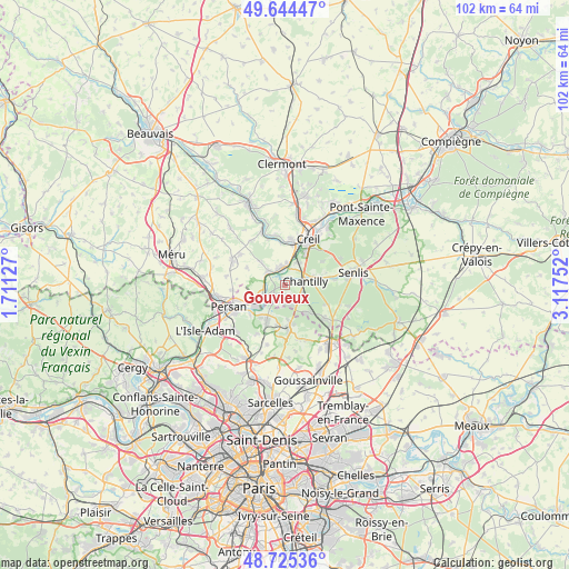
Gouvieux GPS coordinates[2]
49° 11' 13.38" North, 2° 24' 51.804" East
| Map corner | latitude | longitude |
|---|---|---|
| Upper-left | 49.64447°, | 1.71127° |
| Center: | 49.18705°, | 2.41439° |
| Lower-right: | 48.72536°, | 3.11752° |
| Map W x H: | 102.2×102.2 km | = 63.5×63.5mi |
| max Lat: | 51.07786° ⇑16% North |
| Gouvieux: | 49.18705° |
| min Lat: | ⇓84% South 41.3874° |
| min Long | Gouvieux | max Long |
| -5.08615° | 2.41439° | 9.52242° |
| W 49.1%⇐ | ⇒50.9% E |
Elevation
Elevation of Gouvieux is 32 m = 105 ft, and this is 161.7 m = 531 ft below average elevation for this country.
| Max E: |
2333 m = 7654 ft | 89.1% |
| Avg. | 193.7 m = 635 ft | |
| Gouvieux | 32 m = 105 ft | |
Min E: |
-1 m = -3 ft | 10.9% |
See also: France elevation on elevation.city.
Geographical zone
Gouvieux is located in North temperate zone (between Tropic of Cancer and the Arctic Circle). Distance of this North polar circle is 1932.1 km =1200.6 mi to North.| Distance of | km | miles | from Gouvieux |
|---|---|---|---|
| North Pole | 4538 | 2819.8 | to North |
| Arctic Circle | 1932.1 | 1200.6 | to North |
| Tropic Cancer | 2863.2 | 1779.1 | to South |
| Equator | 5469.1 | 3398.3 | to South |


Nearby cities:
15 places around Gouvieux: (largest is in red/bold)
• Asnières-sur-Oise
7.3 km =4.5 mi,  215°
215°
• Blaincourt-lès-Précy
7 km =4.3 mi,  317°
317°
• Boran-sur-Oise
4.7 km =2.9 mi,  241°
241°
• Bruyères-sur-Oise
7.2 km =4.5 mi, 243°
• Chantilly
4.2 km =2.6 mi,  78°
78°
• Chaumontel
7.1 km =4.4 mi,  169°
169°
• Coye-la-Forêt
6.4 km =4 mi,  140°
140°
• Lamorlaye
3.6 km =2.2 mi, 139°
• Précy-sur-Oise
3.8 km =2.4 mi,  307°
307°
• Saint-Maximin
4.8 km =3 mi,  36°
36°
• Seugy
7.4 km =4.6 mi,  191°
191°
• Thiverny
7.4 km =4.6 mi,  12°
12°
• Viarmes
7 km =4.3 mi,  206°
206°
• Villers-sous-Saint-Leu
3.2 km =2 mi,  333°
333°
• Vineuil-Saint-Firmin
6.1 km =3.8 mi, 76°
Sources, notices
• [Note1] Compared only with cities in France existing in our database
• [Src1] Map data: © OpenStreetMap contributors (CC-BY-SA)
• [Src2] Other city data from geonames.org with taken over terms of usage.
• [Src3] Geographical zone / Annual Mean Temperature by Robert A. Rohde @ Wikipedia
