Ségoufielle geodata
Ségoufielle (Occitanie) is a populated place; located in France in Europe/Paris (GMT+2) time zone. With population of 678 people, there are 12092 cities with bigger population in this country. Compared to other cities in France, 91.5% of cities are located further ↑North; 67.6% of cities are located further →East and 54.7% of cities have lower elevation than Ségoufielle. Note1


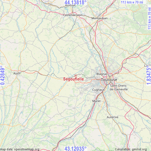
Ségoufielle GPS coordinates[2]
43° 37' 53.112" North, 1° 7' 53.832" East
| Map corner | latitude | longitude |
|---|---|---|
| Upper-left | 44.13818°, | 0.42849° |
| Center: | 43.63142°, | 1.13162° |
| Lower-right: | 43.12035°, | 1.83475° |
| Map W x H: | 113.2×113.2 km | = 70.3×70.3mi |
| max Lat: | 51.07786° ⇑91.5% North |
| Ségoufielle: | 43.63142° |
| min Lat: | ⇓8.5% South 41.3874° |
| min Long | Ségoufielle | max Long |
| -5.08615° | 1.13162° | 9.52242° |
| W 32.4%⇐ | ⇒67.6% E |
Elevation
Elevation of Ségoufielle is 149 m = 489 ft, and this is 44.7 m = 147 ft below average elevation for this country.
| Max E: |
2333 m = 7654 ft | 45.3% |
| Avg. | 193.7 m = 635 ft | |
| Ségoufielle | 149 m = 489 ft | |
Min E: |
-1 m = -3 ft | 54.7% |
See also: France elevation on elevation.city.
Geographical zone
Ségoufielle is located in North temperate zone (between Tropic of Cancer and the Arctic Circle). Distance of this Northern Tropic circle is 2245.4 km =1395.2 mi to South.| Distance of | km | miles | from Ségoufielle |
|---|---|---|---|
| North Pole | 5155.7 | 3203.6 | to North |
| Arctic Circle | 2549.8 | 1584.4 | to North |
| Tropic Cancer | 2245.4 | 1395.2 | to South |
| Equator | 4851.4 | 3014.5 | to South |


Nearby cities:
15 places around Ségoufielle: (largest is in red/bold)
• Auradé
9.4 km =5.8 mi,  219°
219°
• Bonrepos-sur-Aussonnelle
9.6 km =6 mi,  172°
172°
• Brax
8.8 km =5.5 mi,  99°
99°
• Cadours
12.6 km =7.8 mi,  328°
328°
• Fontenilles
10 km =6.2 mi,  151°
151°
• Lasserre
3 km =1.9 mi,  73°
73°
• Le Castéra
4.7 km =2.9 mi,  9°
9°
• Léguevin
8.8 km =5.5 mi,  113°
113°
• Lévignac
6.8 km =4.2 mi,  54°
54°
• L’Isle-Jourdain
4.5 km =2.8 mi,  241°
241°
• Montaigut-sur-Save
10.3 km =6.4 mi, 51°
• Pibrac
12.4 km =7.7 mi, 95°
• Pujaudran
4.9 km =3 mi,  162°
162°
• Saiguède
11.5 km =7.1 mi,  175°
175°
• Thil
9.3 km =5.8 mi, 13°
Sources, notices
• [Note1] Compared only with cities in France existing in our database
• [Src1] Map data: © OpenStreetMap contributors (CC-BY-SA)
• [Src2] Other city data from geonames.org with taken over terms of usage.
• [Src3] Geographical zone / Annual Mean Temperature by Robert A. Rohde @ Wikipedia
