Cadours geodata
Cadours (Occitanie) is a populated place; located in France in Europe/Paris (GMT+2) time zone. With population of 791 people, there are 10703 cities with bigger population in this country. Compared to other cities in France, 90% of cities are located further ↑North; 68.3% of cities are located further →East and 73.2% of cities have lower elevation than Cadours. Note1
Administrative division(s):
- Level 1: Occitanie
- Level 2: Haute-Garonne
- Level 3: Arrondissement de Toulouse
- Level 4: Cadours


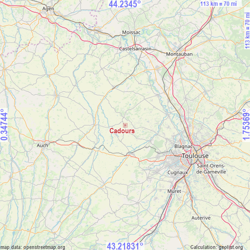
Cadours GPS coordinates[2]
43° 43' 42.816" North, 1° 3' 2.052" East
| Map corner | latitude | longitude |
|---|---|---|
| Upper-left | 44.2345°, | 0.34744° |
| Center: | 43.72856°, | 1.05057° |
| Lower-right: | 43.21831°, | 1.75369° |
| Map W x H: | 113×113 km | = 70.2×70.2mi |
| max Lat: | 51.07786° ⇑90% North |
| Cadours: | 43.72856° |
| min Lat: | ⇓10% South 41.3874° |
| min Long | Cadours | max Long |
| -5.08615° | 1.05057° | 9.52242° |
| W 31.7%⇐ | ⇒68.3% E |
Elevation
Elevation of Cadours is 237 m = 778 ft, and this is 43.3 m = 142 ft above average elevation for this country.
| Max E: |
2333 m = 7654 ft | 26.8% |
| Cadours | 237 m 778 ft | |
| Avg. | 193.7 m = 635 ft | |
Min E: |
-1 m = -3 ft | 73.2% |
See also: France elevation on elevation.city.
Geographical zone
Cadours is located in North temperate zone (between Tropic of Cancer and the Arctic Circle). Distance of this Northern Tropic circle is 2256.2 km =1401.9 mi to South.| Distance of | km | miles | from Cadours |
|---|---|---|---|
| North Pole | 5144.9 | 3196.9 | to North |
| Arctic Circle | 2539 | 1577.7 | to North |
| Tropic Cancer | 2256.2 | 1401.9 | to South |
| Equator | 4862.2 | 3021.2 | to South |


Nearby cities:
15 places around Cadours: (largest is in red/bold)
• Aucamville
15.5 km =9.6 mi,  58°
58°
• Cologne
5.9 km =3.7 mi,  263°
263°
• Escornebœuf
14.9 km =9.3 mi,  234°
234°
• Lasserre
13.7 km =8.5 mi,  136°
136°
• Launac
10.7 km =6.6 mi,  80°
80°
• Le Castéra
9.5 km =5.9 mi,  130°
130°
• Lévignac
13.8 km =8.6 mi,  119°
119°
• L’Isle-Jourdain
13.2 km =8.2 mi,  168°
168°
• Mauvezin
13.9 km =8.6 mi,  270°
270°
• Monferran-Savès
15.6 km =9.7 mi,  201°
201°
• Montaigut-sur-Save
15.2 km =9.4 mi,  106°
106°
• Savenès
16.5 km =10.3 mi,  46°
46°
• Ségoufielle
12.6 km =7.8 mi,  148°
148°
• Thil
8.8 km =5.5 mi,  101°
101°
• Touget
11.8 km =7.3 mi,  248°
248°
Sources, notices
• [Note1] Compared only with cities in France existing in our database
• [Src1] Map data: © OpenStreetMap contributors (CC-BY-SA)
• [Src2] Other city data from geonames.org with taken over terms of usage.
• [Src3] Geographical zone / Annual Mean Temperature by Robert A. Rohde @ Wikipedia
