Argences geodata
Argences (Normandy) is a populated place; located in France in Europe/Paris (GMT+2) time zone. With population of 3,405 people, there are 2861 cities with bigger population in this country. Compared to other cities in France, 82.8% of cities are located further ↓South; 79.3% of cities are located further →East and 95% of cities have higher elevation than Argences. Note1
Administrative division(s):
- Level 1: Normandy
- Level 2: Calvados
- Level 3: Arrondissement de Caen
- Level 4: Argences


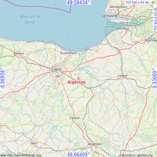
Argences GPS coordinates[2]
49° 7' 34.86" North, 0° 9' 59.184" West
| Map corner | latitude | longitude |
|---|---|---|
| Upper-left | 49.58434°, | -0.86956° |
| Center: | 49.12635°, | -0.16644° |
| Lower-right: | 48.66409°, | 0.53669° |
| Map W x H: | 102.3×102.3 km | = 63.6×63.6mi |
| max Lat: | 51.07786° ⇑17.2% North |
| Argences: | 49.12635° |
| min Lat: | ⇓82.8% South 41.3874° |
| min Long | Argences | max Long |
| -5.08615° | -0.16644° | 9.52242° |
| W 20.7%⇐ | ⇒79.3% E |
Elevation
Elevation of Argences is 17 m = 56 ft, and this is 176.7 m = 580 ft below average elevation for this country.
| Max E: |
2333 m = 7654 ft | 95% |
| Avg. | 193.7 m = 635 ft | |
| Argences | 17 m = 56 ft | |
Min E: |
-1 m = -3 ft | 5% |
See also: France elevation on elevation.city.
Geographical zone
Argences is located in North temperate zone (between Tropic of Cancer and the Arctic Circle). Distance of this North polar circle is 1938.8 km =1204.7 mi to North.| Distance of | km | miles | from Argences |
|---|---|---|---|
| North Pole | 4544.7 | 2823.9 | to North |
| Arctic Circle | 1938.8 | 1204.7 | to North |
| Tropic Cancer | 2856.4 | 1774.9 | to South |
| Equator | 5462.3 | 3394.1 | to South |


Nearby cities:
15 places around Argences: (largest is in red/bold)
• Airan
3 km =1.9 mi,  159°
159°
• Bellengreville
3.1 km =1.9 mi,  265°
265°
• Bourguébus
9.6 km =6 mi, 267°
• Cagny
6.9 km =4.3 mi,  288°
288°
• Canon
8 km =5 mi,  137°
137°
• Chicheboville
4 km =2.5 mi,  242°
242°
• Garcelles-Secqueville
9.5 km =5.9 mi,  251°
251°
• Grentheville
9.1 km =5.7 mi, 285°
• Moult
1.3 km =0.8 mi,  174°
174°
• Méry-Corbon
6.2 km =3.9 mi,  80°
80°
• Saint-Sylvain
8.6 km =5.3 mi,  205°
205°
• Sannerville
7.3 km =4.5 mi,  324°
324°
• Soliers
9.5 km =5.9 mi,  275°
275°
• Troarn
5.9 km =3.7 mi,  349°
349°
• Vimont
2.4 km =1.5 mi,  258°
258°
Sources, notices
• [Note1] Compared only with cities in France existing in our database
• [Src1] Map data: © OpenStreetMap contributors (CC-BY-SA)
• [Src2] Other city data from geonames.org with taken over terms of usage.
• [Src3] Geographical zone / Annual Mean Temperature by Robert A. Rohde @ Wikipedia
