Airan geodata
Airan (Normandy) is a populated place; located in France in Europe/Paris (GMT+2) time zone. With population of 728 people, there are 11431 cities with bigger population in this country. Compared to other cities in France, 82.2% of cities are located further ↓South; 79.2% of cities are located further →East and 88.6% of cities have higher elevation than Airan. Note1
Administrative division(s):
- Level 1: Normandy
- Level 2: Calvados
- Level 3: Arrondissement de Caen
- Level 4: Valambray


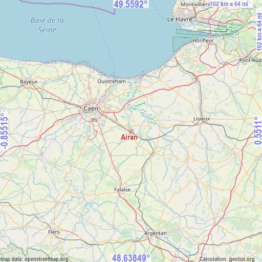
Airan GPS coordinates[2]
49° 6' 3.528" North, 0° 9' 7.308" West
| Map corner | latitude | longitude |
|---|---|---|
| Upper-left | 49.5592°, | -0.85515° |
| Center: | 49.10098°, | -0.15203° |
| Lower-right: | 48.63849°, | 0.5511° |
| Map W x H: | 102.4×102.4 km | = 63.6×63.6mi |
| max Lat: | 51.07786° ⇑17.8% North |
| Airan: | 49.10098° |
| min Lat: | ⇓82.2% South 41.3874° |
| min Long | Airan | max Long |
| -5.08615° | -0.15203° | 9.52242° |
| W 20.8%⇐ | ⇒79.2% E |
Elevation
Elevation of Airan is 33 m = 108 ft, and this is 160.7 m = 527 ft below average elevation for this country.
| Max E: |
2333 m = 7654 ft | 88.6% |
| Avg. | 193.7 m = 635 ft | |
| Airan | 33 m = 108 ft | |
Min E: |
-1 m = -3 ft | 11.4% |
See also: France elevation on elevation.city.
Geographical zone
Airan is located in North temperate zone (between Tropic of Cancer and the Arctic Circle). Distance of this North polar circle is 1941.7 km =1206.5 mi to North.| Distance of | km | miles | from Airan |
|---|---|---|---|
| North Pole | 4547.5 | 2825.7 | to North |
| Arctic Circle | 1941.7 | 1206.5 | to North |
| Tropic Cancer | 2853.6 | 1773.1 | to South |
| Equator | 5459.5 | 3392.4 | to South |


Nearby cities:
15 places around Airan: (largest is in red/bold)
• Argences
3 km =1.9 mi,  339°
339°
• Bellengreville
4.9 km =3 mi,  301°
301°
• Bourguébus
10.9 km =6.8 mi,  282°
282°
• Cagny
9.1 km =5.7 mi, 303°
• Canon
5.3 km =3.3 mi,  124°
124°
• Chicheboville
4.7 km =2.9 mi, 281°
• Garcelles-Secqueville
10 km =6.2 mi,  268°
268°
• Magny-la-Campagne
6.8 km =4.2 mi,  148°
148°
• Moult
1.8 km =1.1 mi,  329°
329°
• Méry-Corbon
6.3 km =3.9 mi,  52°
52°
• Saint-Sylvain
6.9 km =4.3 mi,  223°
223°
• Sannerville
10.3 km =6.4 mi, 329°
• Soliers
11.1 km =6.9 mi,  289°
289°
• Troarn
8.9 km =5.5 mi,  345°
345°
• Vimont
4.2 km =2.6 mi, 304°
Sources, notices
• [Note1] Compared only with cities in France existing in our database
• [Src1] Map data: © OpenStreetMap contributors (CC-BY-SA)
• [Src2] Other city data from geonames.org with taken over terms of usage.
• [Src3] Geographical zone / Annual Mean Temperature by Robert A. Rohde @ Wikipedia
