Saints-en-Puisaye geodata
Saints-en-Puisaye (Bourgogne-Franche-Comté) is a populated place; located in France in Europe/Paris (GMT+2) time zone. With population of 595 people, there are 13406 cities with bigger population in this country. Compared to other cities in France, 53% of cities are located further ↓South; 61.5% of cities are located further ←West and 75.6% of cities have lower elevation than Saints-en-Puisaye. Note1
Administrative division(s):
- Level 1: Bourgogne-Franche-Comté
- Level 2: Département de l'Yonne
- Level 3: Auxerre
- Level 4: Saints-en-Puisaye


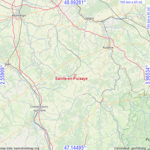
Saints-en-Puisaye GPS coordinates[2]
47° 37' 15.708" North, 3° 15' 43.956" East
| Map corner | latitude | longitude |
|---|---|---|
| Upper-left | 48.09281°, | 2.55909° |
| Center: | 47.62103°, | 3.26221° |
| Lower-right: | 47.14495°, | 3.96534° |
| Map W x H: | 105.4×105.4 km | = 65.5×65.5mi |
| max Lat: | 51.07786° ⇑47% North |
| Saints-en-Puisaye: | 47.62103° |
| min Lat: | ⇓53% South 41.3874° |
| min Long | Saints-en-Puisa | max Long |
| -5.08615° | 3.26221° | 9.52242° |
| W 61.5%⇐ | ⇒38.5% E |
Elevation
Elevation of Saints-en-Puisaye is 254 m = 833 ft, and this is 60.3 m = 198 ft above average elevation for this country.
| Max E: |
2333 m = 7654 ft | 24.4% |
| Saints-en-Puisaye | 254 m 833 ft | |
| Avg. | 193.7 m = 635 ft | |
Min E: |
-1 m = -3 ft | 75.6% |
See also: France elevation on elevation.city.
Geographical zone
Saints-en-Puisaye is located in North temperate zone (between Tropic of Cancer and the Arctic Circle). Distance of this North polar circle is 2106.2 km =1308.7 mi to North.| Distance of | km | miles | from Saints-en-Puisaye |
|---|---|---|---|
| North Pole | 4712.1 | 2928 | to North |
| Arctic Circle | 2106.2 | 1308.7 | to North |
| Tropic Cancer | 2689 | 1670.9 | to South |
| Equator | 5295 | 3290.2 | to South |


Nearby cities:
15 places around Saints-en-Puisaye: (largest is in red/bold)
• Courson-les-Carrières
17.9 km =11.1 mi,  92°
92°
• Diges
15.7 km =9.8 mi,  40°
40°
• Entrains-sur-Nohain
17.4 km =10.8 mi,  181°
181°
• Escamps
19.9 km =12.4 mi,  52°
52°
• Fontenailles
17 km =10.6 mi,  117°
117°
• Mézilles
11.1 km =6.9 mi,  324°
324°
• Ouanne
12.5 km =7.8 mi,  69°
69°
• Parly
17.2 km =10.7 mi,  21°
21°
• Pourrain
18.7 km =11.6 mi, 36°
• Saint-Amand-en-Puisaye
17.4 km =10.8 mi,  234°
234°
• Saint-Fargeau
14.5 km =9 mi,  278°
278°
• Saint-Sauveur-en-Puisaye
4.8 km =3 mi,  267°
267°
• Toucy
13 km =8.1 mi,  10°
10°
• Treigny
9.9 km =6.2 mi,  216°
216°
• Étais-la-Sauvin
14.5 km =9 mi,  154°
154°
Sources, notices
• [Note1] Compared only with cities in France existing in our database
• [Src1] Map data: © OpenStreetMap contributors (CC-BY-SA)
• [Src2] Other city data from geonames.org with taken over terms of usage.
• [Src3] Geographical zone / Annual Mean Temperature by Robert A. Rohde @ Wikipedia
