Saint-Fargeau geodata
Saint-Fargeau (Bourgogne-Franche-Comté) is a populated place; located in France in Europe/Paris (GMT+2) time zone. With population of 1,674 people, there are 5592 cities with bigger population in this country. Compared to other cities in France, 53.3% of cities are located further ↓South; 58.8% of cities are located further ←West and 64% of cities have lower elevation than Saint-Fargeau. Note1
Administrative division(s):
- Level 1: Bourgogne-Franche-Comté
- Level 2: Département de l'Yonne
- Level 3: Auxerre
- Level 4: Saint-Fargeau


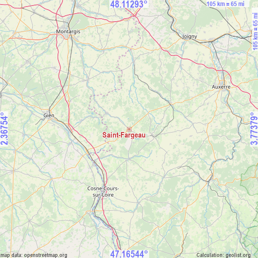
Saint-Fargeau GPS coordinates[2]
47° 38' 28.788" North, 3° 4' 14.376" East
| Map corner | latitude | longitude |
|---|---|---|
| Upper-left | 48.11293°, | 2.36754° |
| Center: | 47.64133°, | 3.07066° |
| Lower-right: | 47.16544°, | 3.77379° |
| Map W x H: | 105.4×105.3 km | = 65.5×65.4mi |
| max Lat: | 51.07786° ⇑46.7% North |
| Saint-Fargeau: | 47.64133° |
| min Lat: | ⇓53.3% South 41.3874° |
| min Long | Saint-Fargeau | max Long |
| -5.08615° | 3.07066° | 9.52242° |
| W 58.8%⇐ | ⇒41.2% E |
Elevation
Elevation of Saint-Fargeau is 189 m = 620 ft, and this is 4.7 m = 15 ft below average elevation for this country.
| Max E: |
2333 m = 7654 ft | 36% |
| Avg. | 193.7 m = 635 ft | |
| Saint-Fargeau | 189 m = 620 ft | |
Min E: |
-1 m = -3 ft | 64% |
See also: France elevation on elevation.city.
Geographical zone
Saint-Fargeau is located in North temperate zone (between Tropic of Cancer and the Arctic Circle). Distance of this North polar circle is 2104 km =1307.4 mi to North.| Distance of | km | miles | from Saint-Fargeau |
|---|---|---|---|
| North Pole | 4709.8 | 2926.5 | to North |
| Arctic Circle | 2104 | 1307.4 | to North |
| Tropic Cancer | 2691.3 | 1672.3 | to South |
| Equator | 5297.2 | 3291.5 | to South |


Nearby cities:
15 places around Saint-Fargeau: (largest is in red/bold)
• Alligny-Cosne
20.9 km =13 mi,  182°
182°
• Arquian
12.7 km =7.9 mi,  209°
209°
• Bléneau
11.1 km =6.9 mi,  305°
305°
• Bonny-sur-Loire
19.5 km =12.1 mi,  242°
242°
• Champignelles
15.4 km =9.6 mi,  1°
1°
• Mézilles
10.4 km =6.5 mi,  49°
49°
• Neuvy-sur-Loire
19.2 km =11.9 mi,  226°
226°
• Ouzouer-sur-Trézée
20 km =12.4 mi,  280°
280°
• Rogny-les-Sept-Écluses
18.5 km =11.5 mi, 310°
• Saint-Amand-en-Puisaye
12.5 km =7.8 mi, 178°
• Saint-Privé
7.1 km =4.4 mi, 311°
• Saint-Sauveur-en-Puisaye
9.9 km =6.2 mi,  104°
104°
• Saints-en-Puisaye
14.5 km =9 mi, 98°
• Toucy
19.8 km =12.3 mi,  57°
57°
• Treigny
13.2 km =8.2 mi,  140°
140°
Sources, notices
• [Note1] Compared only with cities in France existing in our database
• [Src1] Map data: © OpenStreetMap contributors (CC-BY-SA)
• [Src2] Other city data from geonames.org with taken over terms of usage.
• [Src3] Geographical zone / Annual Mean Temperature by Robert A. Rohde @ Wikipedia
