Saint-Tropez geodata
Saint-Tropez (Provence-Alpes-Côte d'Azur) is a populated place; located in France in Europe/Paris (GMT+2) time zone. With population of 5,939 people, there are 1663 cities with bigger population in this country. Compared to other cities in France, 96.3% of cities are located further ↑North; 92.6% of cities are located further ←West and 94.4% of cities have higher elevation than Saint-Tropez. Note1
Administrative division(s):
- Level 1: Provence-Alpes-Côte d'Azur
- Level 2: Var
- Level 3: Arrondissement de Draguignan
- Level 4: Saint-Tropez


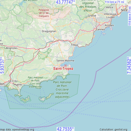
Saint-Tropez GPS coordinates[2]
43° 16' 3.504" North, 6° 38' 25.764" East
| Map corner | latitude | longitude |
|---|---|---|
| Upper-left | 43.77747°, | 5.93737° |
| Center: | 43.26764°, | 6.64049° |
| Lower-right: | 42.7535°, | 7.34362° |
| Map W x H: | 113.9×113.9 km | = 70.8×70.8mi |
| max Lat: | 51.07786° ⇑96.3% North |
| Saint-Tropez: | 43.26764° |
| min Lat: | ⇓3.7% South 41.3874° |
| min Long | Saint-Tropez | max Long |
| -5.08615° | 6.64049° | 9.52242° |
| W 92.6%⇐ | ⇒7.4% E |
Elevation
Elevation of Saint-Tropez is 19 m = 62 ft, and this is 174.7 m = 573 ft below average elevation for this country.
| Max E: |
2333 m = 7654 ft | 94.4% |
| Avg. | 193.7 m = 635 ft | |
| Saint-Tropez | 19 m = 62 ft | |
Min E: |
-1 m = -3 ft | 5.6% |
See also: France elevation on elevation.city.
Geographical zone
Saint-Tropez is located in North temperate zone (between Tropic of Cancer and the Arctic Circle). Distance of this Northern Tropic circle is 2205 km =1370.1 mi to South.| Distance of | km | miles | from Saint-Tropez |
|---|---|---|---|
| North Pole | 5196.2 | 3228.8 | to North |
| Arctic Circle | 2590.3 | 1609.5 | to North |
| Tropic Cancer | 2205 | 1370.1 | to South |
| Equator | 4810.9 | 2989.4 | to South |


Nearby cities:
15 places around Saint-Tropez: (largest is in red/bold)
• Cavalaire-sur-Mer
13.9 km =8.6 mi,  220°
220°
• Cogolin
9.1 km =5.7 mi,  259°
259°
• Fréjus
20 km =12.4 mi,  22°
22°
• Gassin
6.2 km =3.9 mi,  225°
225°
• Grimaud
9.6 km =6 mi,  273°
273°
• La Croix-Valmer
8.9 km =5.5 mi, 221°
• La Garde-Freinet
14.9 km =9.3 mi,  291°
291°
• La Môle
15.6 km =9.7 mi,  244°
244°
• Le Plan-de-la-Tour
10.3 km =6.4 mi,  314°
314°
• Les Mayons
23.4 km =14.5 mi,  282°
282°
• Puget-sur-Argens
21.2 km =13.2 mi,  9°
9°
• Ramatuelle
6.2 km =3.9 mi,  202°
202°
• Roquebrune-sur-Argens
19.5 km =12.1 mi,  359°
359°
• Saint-Raphaël
20.4 km =12.7 mi,  31°
31°
• Sainte-Maxime
4.6 km =2.9 mi, 357°
Sources, notices
• [Note1] Compared only with cities in France existing in our database
• [Src1] Map data: © OpenStreetMap contributors (CC-BY-SA)
• [Src2] Other city data from geonames.org with taken over terms of usage.
• [Src3] Geographical zone / Annual Mean Temperature by Robert A. Rohde @ Wikipedia
