Saint-Quentin-en-Mauges geodata
Saint-Quentin-en-Mauges (Pays de la Loire) is a populated place; located in France in Europe/Paris (GMT+2) time zone. With population of 1,047 people, there are 8486 cities with bigger population in this country. Compared to other cities in France, 51.6% of cities are located further ↑North; 87.4% of cities are located further →East and 51.4% of cities have higher elevation than Saint-Quentin-en-Mauges. Note1
Administrative division(s):
- Level 1: Pays de la Loire
- Level 2: Département de Maine-et-Loire
- Level 3: Arrondissement de Cholet
- Level 4: Montrevault-sur-Èvre
Current local time in Saint-Quentin-en-Mauges:
11:29 AM, SaturdayDifference from your time zone: hours


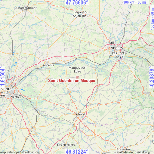
Saint-Quentin-en-Mauges GPS coordinates[2]
47° 17' 28.68" North, 0° 54' 42.876" West
| Map corner | latitude | longitude |
|---|---|---|
| Upper-left | 47.76606°, | -1.61504° |
| Center: | 47.2913°, | -0.91191° |
| Lower-right: | 46.81224°, | -0.20879° |
| Map W x H: | 106.1×106.1 km | = 65.9×65.9mi |
| max Lat: | 51.07786° ⇑51.6% North |
| Saint-Quentin-en-Mauges: | 47.2913° |
| min Lat: | ⇓48.4% South 41.3874° |
| min Long | Saint-Quentin-e | max Long |
| -5.08615° | -0.91191° | 9.52242° |
| W 12.6%⇐ | ⇒87.4% E |
Elevation
Elevation of Saint-Quentin-en-Mauges is 127 m = 417 ft, and this is 66.7 m = 219 ft below average elevation for this country.
| Max E: |
2333 m = 7654 ft | 51.4% |
| Avg. | 193.7 m = 635 ft | |
| Saint-Quentin-en-Mauges | 127 m = 417 ft | |
Min E: |
-1 m = -3 ft | 48.6% |
See also: France elevation on elevation.city.
Geographical zone
Saint-Quentin-en-Mauges is located in North temperate zone (between Tropic of Cancer and the Arctic Circle). Distance of this North polar circle is 2142.9 km =1331.5 mi to North.| Distance of | km | miles | from Saint-Quentin-en-Mauges |
|---|---|---|---|
| North Pole | 4748.8 | 2950.8 | to North |
| Arctic Circle | 2142.9 | 1331.5 | to North |
| Tropic Cancer | 2652.4 | 1648.1 | to South |
| Equator | 5258.3 | 3267.4 | to South |


Nearby cities:
15 places around Saint-Quentin-en-Mauges: (largest is in red/bold)
• Botz-en-Mauges
7 km =4.3 mi,  284°
284°
• Bourgneuf-en-Mauges
6.2 km =3.9 mi,  67°
67°
• Chaudron-en-Mauges
5.6 km =3.5 mi,  266°
266°
• Jallais
11 km =6.8 mi,  162°
162°
• La Pommeraye
8.2 km =5.1 mi,  29°
29°
• La Salle-et-Chapelle-Aubry
6.6 km =4.1 mi,  226°
226°
• Le Mesnil-en-Vallée
8.4 km =5.2 mi,  348°
348°
• Le Pin-en-Mauges
4.3 km =2.7 mi,  167°
167°
• Montrevault
10.8 km =6.7 mi,  250°
250°
• Neuvy-en-Mauges
7.1 km =4.4 mi,  112°
112°
• Saint-Florent-le-Vieil
11 km =6.8 mi,  314°
314°
• Saint-Laurent-de-la-Plaine
8.7 km =5.4 mi, 70°
• Saint-Laurent-du-Mottay
7.2 km =4.5 mi,  336°
336°
• Saint-Pierre-Montlimart
9 km =5.6 mi, 254°
• Sainte-Christine
4.8 km =3 mi,  96°
96°
Sources, notices
• [Note1] Compared only with cities in France existing in our database
• [Src1] Map data: © OpenStreetMap contributors (CC-BY-SA)
• [Src2] Other city data from geonames.org with taken over terms of usage.
• [Src3] Geographical zone / Annual Mean Temperature by Robert A. Rohde @ Wikipedia
