Botz-en-Mauges geodata
Botz-en-Mauges (Pays de la Loire) is a populated place; located in France in Europe/Paris (GMT+2) time zone. With population of 712 people, there are 11628 cities with bigger population in this country. Compared to other cities in France, 51.4% of cities are located further ↑North; 88.2% of cities are located further →East and 60.4% of cities have higher elevation than Botz-en-Mauges. Note1
Administrative division(s):
- Level 1: Pays de la Loire
- Level 2: Département de Maine-et-Loire
- Level 3: Arrondissement de Cholet
- Level 4: Mauges-sur-Loire


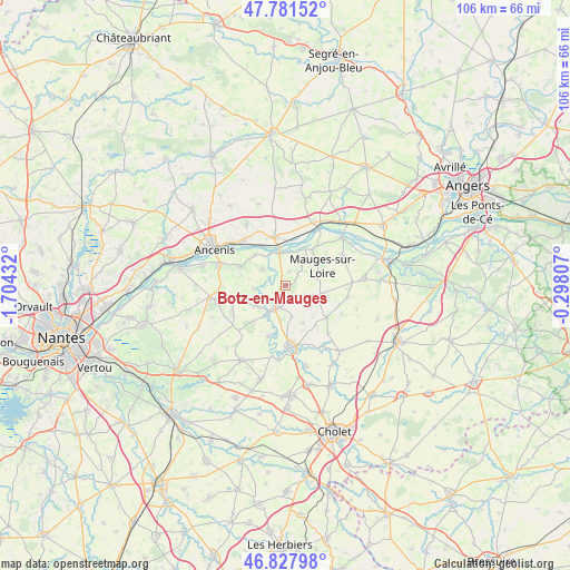
Botz-en-Mauges GPS coordinates[2]
47° 18' 24.84" North, 1° 0' 4.284" West
| Map corner | latitude | longitude |
|---|---|---|
| Upper-left | 47.78152°, | -1.70432° |
| Center: | 47.3069°, | -1.00119° |
| Lower-right: | 46.82798°, | -0.29807° |
| Map W x H: | 106×106 km | = 65.9×65.9mi |
| max Lat: | 51.07786° ⇑51.4% North |
| Botz-en-Mauges: | 47.3069° |
| min Lat: | ⇓48.6% South 41.3874° |
| min Long | Botz-en-Mauges | max Long |
| -5.08615° | -1.00119° | 9.52242° |
| W 11.8%⇐ | ⇒88.2% E |
Elevation
Elevation of Botz-en-Mauges is 101 m = 331 ft, and this is 92.7 m = 304 ft below average elevation for this country.
| Max E: |
2333 m = 7654 ft | 60.4% |
| Avg. | 193.7 m = 635 ft | |
| Botz-en-Mauges | 101 m = 331 ft | |
Min E: |
-1 m = -3 ft | 39.6% |
See also: France elevation on elevation.city.
Geographical zone
Botz-en-Mauges is located in North temperate zone (between Tropic of Cancer and the Arctic Circle). Distance of this North polar circle is 2141.1 km =1330.4 mi to North.| Distance of | km | miles | from Botz-en-Mauges |
|---|---|---|---|
| North Pole | 4747 | 2949.6 | to North |
| Arctic Circle | 2141.1 | 1330.4 | to North |
| Tropic Cancer | 2654.1 | 1649.2 | to South |
| Equator | 5260 | 3268.4 | to South |


Nearby cities:
15 places around Botz-en-Mauges: (largest is in red/bold)
• Bouzillé
9 km =5.6 mi,  292°
292°
• Chaudron-en-Mauges
2.4 km =1.5 mi,  150°
150°
• La Chapelle-Saint-Florent
5.1 km =3.2 mi,  305°
305°
• La Salle-et-Chapelle-Aubry
6.6 km =4.1 mi,  162°
162°
• Le Fuilet
8.8 km =5.5 mi,  252°
252°
• Le Marillais
8 km =5 mi, 314°
• Le Mesnil-en-Vallée
8.2 km =5.1 mi,  37°
37°
• Le Pin-en-Mauges
9.7 km =6 mi,  127°
127°
• Montrevault
6.3 km =3.9 mi,  213°
213°
• Saint-Florent-le-Vieil
6.1 km =3.8 mi,  350°
350°
• Saint-Laurent-du-Mottay
6.3 km =3.9 mi, 38°
• Saint-Pierre-Montlimart
4.6 km =2.9 mi, 205°
• Saint-Quentin-en-Mauges
7 km =4.3 mi,  104°
104°
• Saint-Rémy-en-Mauges
6.8 km =4.2 mi,  235°
235°
• Varades
8.9 km =5.5 mi, 346°
Sources, notices
• [Note1] Compared only with cities in France existing in our database
• [Src1] Map data: © OpenStreetMap contributors (CC-BY-SA)
• [Src2] Other city data from geonames.org with taken over terms of usage.
• [Src3] Geographical zone / Annual Mean Temperature by Robert A. Rohde @ Wikipedia
