Saint-Pierre-des-Landes geodata
Saint-Pierre-des-Landes (Pays de la Loire) is a populated place; located in France in Europe/Paris (GMT+2) time zone. With population of 985 people, there are 8948 cities with bigger population in this country. Compared to other cities in France, 64.1% of cities are located further ↓South; 88.4% of cities are located further →East and 51.9% of cities have lower elevation than Saint-Pierre-des-Landes. Note1
Administrative division(s):
- Level 1: Pays de la Loire
- Level 2: Mayenne
- Level 3: Arrondissement de Mayenne
- Level 4: Saint-Pierre-des-Landes
Current local time in Saint-Pierre-des-Landes:
11:18 PM, SaturdayDifference from your time zone: hours


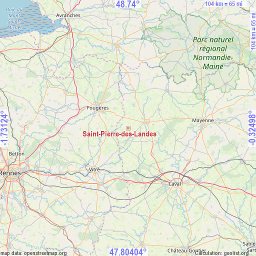
Saint-Pierre-des-Landes GPS coordinates[2]
48° 16' 26.976" North, 1° 1' 41.196" West
| Map corner | latitude | longitude |
|---|---|---|
| Upper-left | 48.74°, | -1.73124° |
| Center: | 48.27416°, | -1.02811° |
| Lower-right: | 47.80404°, | -0.32498° |
| Map W x H: | 104.1×104.1 km | = 64.7×64.7mi |
| max Lat: | 51.07786° ⇑35.9% North |
| Saint-Pierre-des-Landes: | 48.27416° |
| min Lat: | ⇓64.1% South 41.3874° |
| min Long | Saint-Pierre-de | max Long |
| -5.08615° | -1.02811° | 9.52242° |
| W 11.6%⇐ | ⇒88.4% E |
Elevation
Elevation of Saint-Pierre-des-Landes is 139 m = 456 ft, and this is 54.7 m = 179 ft below average elevation for this country.
| Max E: |
2333 m = 7654 ft | 48.1% |
| Avg. | 193.7 m = 635 ft | |
| Saint-Pierre-des-Landes | 139 m = 456 ft | |
Min E: |
-1 m = -3 ft | 51.9% |
See also: France elevation on elevation.city.
Geographical zone
Saint-Pierre-des-Landes is located in North temperate zone (between Tropic of Cancer and the Arctic Circle). Distance of this North polar circle is 2033.6 km =1263.6 mi to North.| Distance of | km | miles | from Saint-Pierre-des-Landes |
|---|---|---|---|
| North Pole | 4639.5 | 2882.9 | to North |
| Arctic Circle | 2033.6 | 1263.6 | to North |
| Tropic Cancer | 2761.7 | 1716 | to South |
| Equator | 5367.6 | 3335.3 | to South |


Nearby cities:
15 places around Saint-Pierre-des-Landes: (largest is in red/bold)
• Beaucé
12 km =7.5 mi,  306°
306°
• Bourgon
12.3 km =7.6 mi,  193°
193°
• Châtillon-en-Vendelais
12.3 km =7.6 mi,  243°
243°
• Dompierre-du-Chemin
8.4 km =5.2 mi,  263°
263°
• Ernée
7.6 km =4.7 mi,  69°
69°
• Fleurigné
9.8 km =6.1 mi, 314°
• Juvigné
5.1 km =3.2 mi, 185°
• La Chapelle-Janson
9.8 km =6.1 mi,  326°
326°
• La Croixille
8 km =5 mi,  196°
196°
• La Selle-en-Luitré
8.4 km =5.2 mi,  299°
299°
• Larchamp
9.9 km =6.2 mi,  12°
12°
• Luitré
6.8 km =4.2 mi,  277°
277°
• Montaudin
12.7 km =7.9 mi, 13°
• Montenay
10.1 km =6.3 mi,  81°
81°
• Saint-Hilaire-du-Maine
9 km =5.6 mi,  126°
126°
Sources, notices
• [Note1] Compared only with cities in France existing in our database
• [Src1] Map data: © OpenStreetMap contributors (CC-BY-SA)
• [Src2] Other city data from geonames.org with taken over terms of usage.
• [Src3] Geographical zone / Annual Mean Temperature by Robert A. Rohde @ Wikipedia
