Cormeilles geodata
Cormeilles (Normandy) is a populated place; located in France in Europe/Paris (GMT+2) time zone. With population of 1,273 people, there are 7156 cities with bigger population in this country. Compared to other cities in France, 85.1% of cities are located further ↓South; 74.5% of cities are located further →East and 73.6% of cities have higher elevation than Cormeilles. Note1
Administrative division(s):
- Level 1: Normandy
- Level 2: Département de l'Eure
- Level 3: Arrondissement de Bernay
- Level 4: Cormeilles


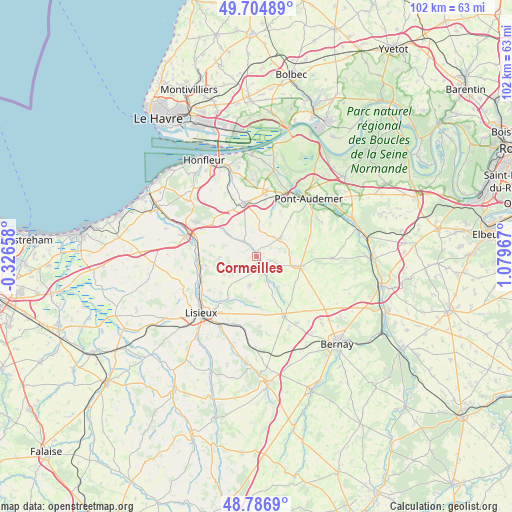
Cormeilles GPS coordinates[2]
49° 14' 52.908" North, 0° 22' 35.544" East
| Map corner | latitude | longitude |
|---|---|---|
| Upper-left | 49.70489°, | -0.32658° |
| Center: | 49.24803°, | 0.37654° |
| Lower-right: | 48.7869°, | 1.07967° |
| Map W x H: | 102.1×102.1 km | = 63.4×63.4mi |
| max Lat: | 51.07786° ⇑14.9% North |
| Cormeilles: | 49.24803° |
| min Lat: | ⇓85.1% South 41.3874° |
| min Long | Cormeilles | max Long |
| -5.08615° | 0.37654° | 9.52242° |
| W 25.5%⇐ | ⇒74.5% E |
Elevation
Elevation of Cormeilles is 70 m = 230 ft, and this is 123.7 m = 406 ft below average elevation for this country.
| Max E: |
2333 m = 7654 ft | 73.6% |
| Avg. | 193.7 m = 635 ft | |
| Cormeilles | 70 m = 230 ft | |
Min E: |
-1 m = -3 ft | 26.4% |
See also: France elevation on elevation.city.
Geographical zone
Cormeilles is located in North temperate zone (between Tropic of Cancer and the Arctic Circle). Distance of this North polar circle is 1925.3 km =1196.3 mi to North.| Distance of | km | miles | from Cormeilles |
|---|---|---|---|
| North Pole | 4531.2 | 2815.6 | to North |
| Arctic Circle | 1925.3 | 1196.3 | to North |
| Tropic Cancer | 2869.9 | 1783.3 | to South |
| Equator | 5475.9 | 3402.6 | to South |


Nearby cities:
15 places around Cormeilles: (largest is in red/bold)
• Beuzeville
11 km =6.8 mi,  347°
347°
• Blangy-le-Château
7.5 km =4.7 mi,  265°
265°
• Bonneville-la-Louvet
4.2 km =2.6 mi,  309°
309°
• Coquainvilliers
13.3 km =8.3 mi,  245°
245°
• Hermival-les-Vaux
11.2 km =7 mi,  218°
218°
• Le Breuil-en-Auge
11.2 km =7 mi,  259°
259°
• Le Pin
5.1 km =3.2 mi, 216°
• Lieurey
9.1 km =5.7 mi,  102°
102°
• Marolles
12.2 km =7.6 mi,  181°
181°
• Moyaux
6.1 km =3.8 mi,  194°
194°
• Ouilly-le-Vicomte
13.3 km =8.3 mi,  236°
236°
• Saint-Philbert-des-Champs
8.1 km =5 mi, 237°
• Thiberville
13.5 km =8.4 mi,  155°
155°
• Tourville-sur-Pont-Audemer
13.3 km =8.3 mi,  48°
48°
• Épaignes
5.8 km =3.6 mi, 52°
Sources, notices
• [Note1] Compared only with cities in France existing in our database
• [Src1] Map data: © OpenStreetMap contributors (CC-BY-SA)
• [Src2] Other city data from geonames.org with taken over terms of usage.
• [Src3] Geographical zone / Annual Mean Temperature by Robert A. Rohde @ Wikipedia
