Mazé geodata
Mazé (Pays de la Loire) is a populated place; located in France in Europe/Paris (GMT+2) time zone. With population of 4,094 people, there are 2399 cities with bigger population in this country. Compared to other cities in France, 50.6% of cities are located further ↓South; 80.5% of cities are located further →East and 90.3% of cities have higher elevation than Mazé. Note1
Administrative division(s):
- Level 1: Pays de la Loire
- Level 2: Département de Maine-et-Loire
- Level 3: Arrondissement de Saumur
- Level 4: Mazé-Milon


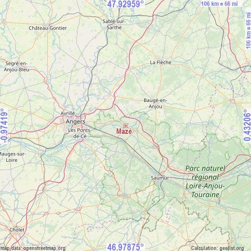
Mazé GPS coordinates[2]
47° 27' 22.752" North, 0° 16' 15.816" West
| Map corner | latitude | longitude |
|---|---|---|
| Upper-left | 47.92959°, | -0.97419° |
| Center: | 47.45632°, | -0.27106° |
| Lower-right: | 46.97875°, | 0.43206° |
| Map W x H: | 105.7×105.7 km | = 65.7×65.7mi |
| max Lat: | 51.07786° ⇑49.4% North |
| Mazé: | 47.45632° |
| min Lat: | ⇓50.6% South 41.3874° |
| min Long | Mazé | max Long |
| -5.08615° | -0.27106° | 9.52242° |
| W 19.5%⇐ | ⇒80.5% E |
Elevation
Elevation of Mazé is 29 m = 95 ft, and this is 164.7 m = 540 ft below average elevation for this country.
| Max E: |
2333 m = 7654 ft | 90.3% |
| Avg. | 193.7 m = 635 ft | |
| Mazé | 29 m = 95 ft | |
Min E: |
-1 m = -3 ft | 9.7% |
See also: France elevation on elevation.city.
Geographical zone
Mazé is located in North temperate zone (between Tropic of Cancer and the Arctic Circle). Distance of this North polar circle is 2124.5 km =1320.1 mi to North.| Distance of | km | miles | from Mazé |
|---|---|---|---|
| North Pole | 4730.4 | 2939.3 | to North |
| Arctic Circle | 2124.5 | 1320.1 | to North |
| Tropic Cancer | 2670.7 | 1659.5 | to South |
| Equator | 5276.6 | 3278.7 | to South |


Nearby cities:
15 places around Mazé: (largest is in red/bold)
• Andard
9.5 km =5.9 mi,  270°
270°
• Bauné
6 km =3.7 mi,  323°
323°
• Beaufort-en-Vallée
4.3 km =2.7 mi,  115°
115°
• Blaison-Gohier
10.2 km =6.3 mi,  231°
231°
• Brion
8.8 km =5.5 mi,  101°
101°
• Corné
6.1 km =3.8 mi,  285°
285°
• Coutures
12.2 km =7.6 mi,  211°
211°
• Fontaine-Guérin
7 km =4.3 mi,  61°
61°
• Jarzé
11.4 km =7.1 mi,  14°
14°
• La Bohalle
10.3 km =6.4 mi,  247°
247°
• La Ménitré
6.3 km =3.9 mi,  176°
176°
• Saint-Georges-des-Sept-Voies
11.9 km =7.4 mi, 184°
• Saint-Mathurin-sur-Loire
5.6 km =3.5 mi,  217°
217°
• Saint-Rémy-la-Varenne
7.3 km =4.5 mi, 206°
• Sarrigné
9.9 km =6.2 mi,  301°
301°
Sources, notices
• [Note1] Compared only with cities in France existing in our database
• [Src1] Map data: © OpenStreetMap contributors (CC-BY-SA)
• [Src2] Other city data from geonames.org with taken over terms of usage.
• [Src3] Geographical zone / Annual Mean Temperature by Robert A. Rohde @ Wikipedia
