Arnac-la-Poste geodata
Arnac-la-Poste (Nouvelle-Aquitaine) is a populated place; located in France in Europe/Paris (GMT+2) time zone. With population of 1,021 people, there are 8676 cities with bigger population in this country. Compared to other cities in France, 62.7% of cities are located further ↑North; 64.7% of cities are located further →East and 81.8% of cities have lower elevation than Arnac-la-Poste. Note1
Administrative division(s):
- Level 1: Nouvelle-Aquitaine
- Level 2: Haute-Vienne
- Level 3: Arrondissement de Bellac
- Level 4: Arnac-la-Poste


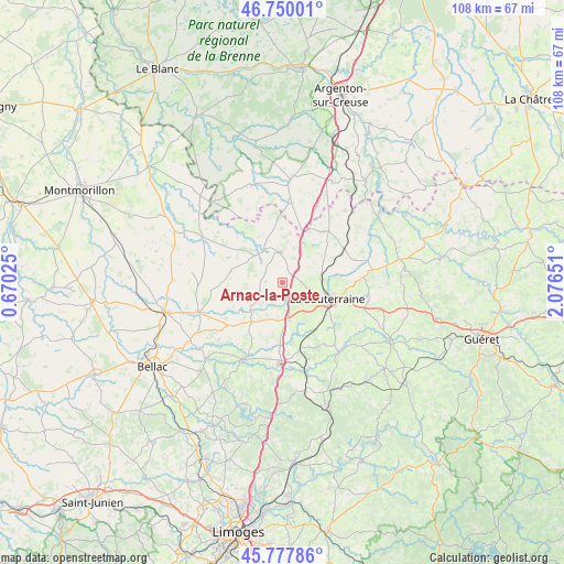
Arnac-la-Poste GPS coordinates[2]
46° 15' 57.924" North, 1° 22' 24.168" East
| Map corner | latitude | longitude |
|---|---|---|
| Upper-left | 46.75001°, | 0.67025° |
| Center: | 46.26609°, | 1.37338° |
| Lower-right: | 45.77786°, | 2.07651° |
| Map W x H: | 108.1×108.1 km | = 67.2×67.2mi |
| max Lat: | 51.07786° ⇑62.7% North |
| Arnac-la-Poste: | 46.26609° |
| min Lat: | ⇓37.3% South 41.3874° |
| min Long | Arnac-la-Poste | max Long |
| -5.08615° | 1.37338° | 9.52242° |
| W 35.3%⇐ | ⇒64.7% E |
Elevation
Elevation of Arnac-la-Poste is 309 m = 1014 ft, and this is 115.3 m = 378 ft above average elevation for this country.
| Max E: |
2333 m = 7654 ft | 18.2% |
| Arnac-la-Poste | 309 m 1014 ft | |
| Avg. | 193.7 m = 635 ft | |
Min E: |
-1 m = -3 ft | 81.8% |
See also: France elevation on elevation.city.
Geographical zone
Arnac-la-Poste is located in North temperate zone (between Tropic of Cancer and the Arctic Circle). Distance of this North polar circle is 2256.9 km =1402.4 mi to North.| Distance of | km | miles | from Arnac-la-Poste |
|---|---|---|---|
| North Pole | 4862.8 | 3021.6 | to North |
| Arctic Circle | 2256.9 | 1402.4 | to North |
| Tropic Cancer | 2538.4 | 1577.3 | to South |
| Equator | 5144.3 | 3196.5 | to South |


Nearby cities:
15 places around Arnac-la-Poste: (largest is in red/bold)
• Azerables
12.4 km =7.7 mi,  38°
38°
• Bessines-sur-Gartempe
17.5 km =10.9 mi,  181°
181°
• Châteauponsac
16.5 km =10.3 mi,  207°
207°
• Fromental
12 km =7.5 mi,  170°
170°
• La Châtre-Langlin
15.9 km =9.9 mi,  4°
4°
• La Souterraine
9.2 km =5.7 mi,  109°
109°
• Magnac-Laval
16.9 km =10.5 mi,  250°
250°
• Saint-Agnant-de-Versillat
10.6 km =6.6 mi,  82°
82°
• Saint-Léger-Magnazeix
10 km =6.2 mi,  284°
284°
• Saint-Maurice-la-Souterraine
7.2 km =4.5 mi,  143°
143°
• Saint-Pierre-de-Fursac
17 km =10.6 mi, 140°
• Saint-Priest-la-Feuille
14.4 km =8.9 mi,  120°
120°
• Saint-Sornin-Leulac
9.5 km =5.9 mi,  218°
218°
• Saint-Sulpice-les-Feuilles
5.8 km =3.6 mi,  355°
355°
• Saint-Étienne-de-Fursac
17.3 km =10.7 mi, 141°
Sources, notices
• [Note1] Compared only with cities in France existing in our database
• [Src1] Map data: © OpenStreetMap contributors (CC-BY-SA)
• [Src2] Other city data from geonames.org with taken over terms of usage.
• [Src3] Geographical zone / Annual Mean Temperature by Robert A. Rohde @ Wikipedia
