Chaillac geodata
Chaillac (Centre) is a populated place; located in France in Europe/Paris (GMT+2) time zone. With population of 1,172 people, there are 7694 cities with bigger population in this country. Compared to other cities in France, 60.7% of cities are located further ↑North; 65.5% of cities are located further →East and 63.3% of cities have lower elevation than Chaillac. Note1
Administrative division(s):
- Level 1: Centre
- Level 2: Département de l'Indre
- Level 3: Le Blanc
- Level 4: Chaillac


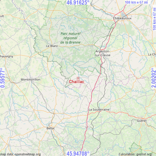
Chaillac GPS coordinates[2]
46° 26' 1.752" North, 1° 17' 56.004" East
| Map corner | latitude | longitude |
|---|---|---|
| Upper-left | 46.91625°, | 0.59577° |
| Center: | 46.43382°, | 1.29889° |
| Lower-right: | 45.94708°, | 2.00202° |
| Map W x H: | 107.8×107.8 km | = 67×67mi |
| max Lat: | 51.07786° ⇑60.7% North |
| Chaillac: | 46.43382° |
| min Lat: | ⇓39.3% South 41.3874° |
| min Long | Chaillac | max Long |
| -5.08615° | 1.29889° | 9.52242° |
| W 34.5%⇐ | ⇒65.5% E |
Elevation
Elevation of Chaillac is 186 m = 610 ft, and this is 7.7 m = 25 ft below average elevation for this country.
| Max E: |
2333 m = 7654 ft | 36.7% |
| Avg. | 193.7 m = 635 ft | |
| Chaillac | 186 m = 610 ft | |
Min E: |
-1 m = -3 ft | 63.3% |
See also: France elevation on elevation.city.
Geographical zone
Chaillac is located in North temperate zone (between Tropic of Cancer and the Arctic Circle). Distance of this North polar circle is 2238.2 km =1390.8 mi to North.| Distance of | km | miles | from Chaillac |
|---|---|---|---|
| North Pole | 4844.1 | 3010 | to North |
| Arctic Circle | 2238.2 | 1390.8 | to North |
| Tropic Cancer | 2557 | 1588.8 | to South |
| Equator | 5163 | 3208.1 | to South |


Nearby cities:
15 places around Chaillac: (largest is in red/bold)
• Arnac-la-Poste
19.5 km =12.1 mi,  162°
162°
• Azerables
16.1 km =10 mi,  123°
123°
• Brigueil-le-Chantre
16.7 km =10.4 mi,  255°
255°
• Bélâbre
16.9 km =10.5 mi,  320°
320°
• Chantôme
19.9 km =12.4 mi,  97°
97°
• La Châtre-Langlin
7.5 km =4.7 mi,  111°
111°
• La Trimouille
20.2 km =12.6 mi,  280°
280°
• Lignac
7.1 km =4.4 mi,  299°
299°
• Lussac-les-Églises
13.7 km =8.5 mi,  224°
224°
• Parnac
11.2 km =7 mi,  78°
78°
• Prissac
8.5 km =5.3 mi,  5°
5°
• Saint-Benoît-du-Sault
7.1 km =4.4 mi, 84°
• Saint-Léger-Magnazeix
16.7 km =10.4 mi,  193°
193°
• Saint-Sulpice-les-Feuilles
13.9 km =8.6 mi, 157°
• Saint-Sébastien
18.4 km =11.4 mi, 104°
Sources, notices
• [Note1] Compared only with cities in France existing in our database
• [Src1] Map data: © OpenStreetMap contributors (CC-BY-SA)
• [Src2] Other city data from geonames.org with taken over terms of usage.
• [Src3] Geographical zone / Annual Mean Temperature by Robert A. Rohde @ Wikipedia
